You are here: Home > Network List > CB - China National Seismic Network Stations List
> Station TIA Taian,Shandong Province > Earthquake Result Viewer
TIA Taian,Shandong Province - Earthquake Result Viewer
| Earthquake location: |
Vanuatu Islands |
| Earthquake latitude/longitude: |
-14.7/167.3 |
| Earthquake time(UTC): |
2012/07/06 (188) 02:28:22 GMT |
| Earthquake Depth: |
160 km |
| Earthquake Magnitude: |
5.7 MB, 6.3 MW, 6.3 MW |
| Earthquake Catalog/Contributor: |
WHDF/NEIC |
|
| Network: |
CB China National Seismic Network |
| Station: |
TIA Taian,Shandong Province |
| Lat/Lon: |
36.21 N/117.12 E |
| Elevation: |
267 m |
|
| Distance: |
69.3 deg |
| Az: |
318.375 deg |
| Baz: |
127.35 deg |
| Ray Param: |
0.055278223 |
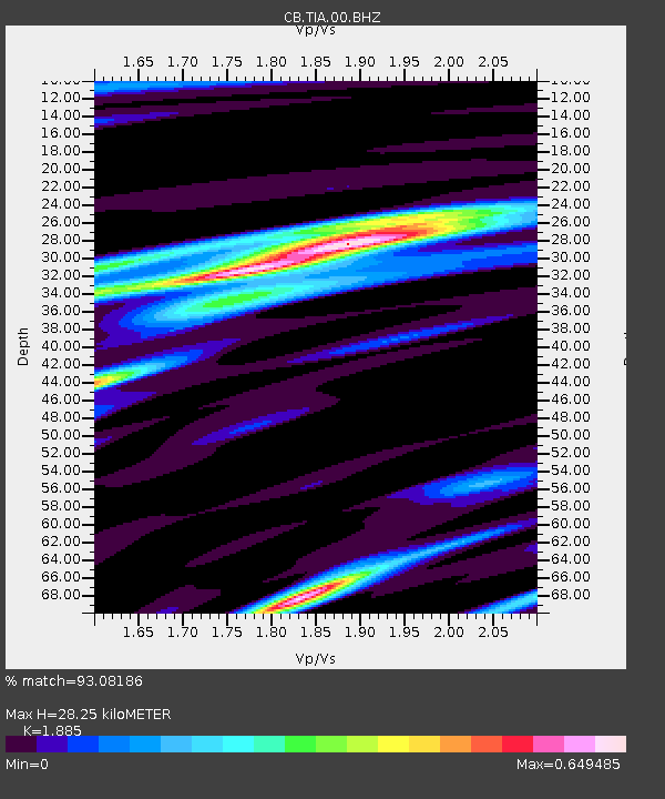
| Estimated Moho Depth: |
28.25 km |
| Estimated Crust Vp/Vs: |
1.88 |
| Assumed Crust Vp: |
6.363 km/s |
| Estimated Crust Vs: |
3.376 km/s |
| Estimated Crust Poisson's Ratio: |
0.30 |
|
| Radial Match: |
93.08186 % |
| Radial Bump: |
297 |
| Transverse Match: |
88.60184 % |
| Transverse Bump: |
378 |
| SOD ConfigId: |
463687 |
| Insert Time: |
2013-02-20 19:15:40.900 +0000 |
| GWidth: |
2.5 |
| Max Bumps: |
400 |
| Tol: |
0.001 |
|

Signal To Noise
| Channel | StoN | STA | LTA |
| CB:TIA:00:BHZ:20120706T02:38:41.400022Z | 20.35519 | 1.7045683E-6 | 8.3741206E-8 |
| CB:TIA:00:BHN:20120706T02:38:41.400022Z | 9.37716 | 6.3680835E-7 | 6.791058E-8 |
| CB:TIA:00:BHE:20120706T02:38:41.400022Z | 6.171169 | 6.2509133E-7 | 1.01292216E-7 |
| Arrivals |
| Ps | 4.1 SECOND |
| PpPs | 12 SECOND |
| PsPs/PpSs | 16 SECOND |


