You are here: Home > Network List > CB - China National Seismic Network Stations List
> Station LYN Luoyang,Henan Province > Earthquake Result Viewer
LYN Luoyang,Henan Province - Earthquake Result Viewer
| Earthquake location: |
Vanuatu Islands |
| Earthquake latitude/longitude: |
-14.7/167.3 |
| Earthquake time(UTC): |
2012/07/06 (188) 02:28:22 GMT |
| Earthquake Depth: |
160 km |
| Earthquake Magnitude: |
5.7 MB, 6.3 MW, 6.3 MW |
| Earthquake Catalog/Contributor: |
WHDF/NEIC |
|
| Network: |
CB China National Seismic Network |
| Station: |
LYN Luoyang,Henan Province |
| Lat/Lon: |
34.55 N/112.47 E |
| Elevation: |
170 m |
|
| Distance: |
71.5 deg |
| Az: |
314.606 deg |
| Baz: |
123.401 deg |
| Ray Param: |
0.05387553 |
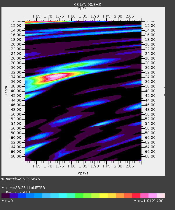
| Estimated Moho Depth: |
33.25 km |
| Estimated Crust Vp/Vs: |
1.73 |
| Assumed Crust Vp: |
6.155 km/s |
| Estimated Crust Vs: |
3.553 km/s |
| Estimated Crust Poisson's Ratio: |
0.25 |
|
| Radial Match: |
95.396645 % |
| Radial Bump: |
400 |
| Transverse Match: |
88.89749 % |
| Transverse Bump: |
400 |
| SOD ConfigId: |
463687 |
| Insert Time: |
2013-02-20 19:15:45.857 +0000 |
| GWidth: |
2.5 |
| Max Bumps: |
400 |
| Tol: |
0.001 |
|

Signal To Noise
| Channel | StoN | STA | LTA |
| CB:LYN:00:BHZ:20120706T02:38:54.369993Z | 41.154644 | 3.1496927E-6 | 7.6533105E-8 |
| CB:LYN:00:BHN:20120706T02:38:54.369993Z | 10.205649 | 6.8813205E-7 | 6.742658E-8 |
| CB:LYN:00:BHE:20120706T02:38:54.369993Z | 16.761307 | 1.0142662E-6 | 6.051236E-8 |
| Arrivals |
| Ps | 4.1 SECOND |
| PpPs | 14 SECOND |
| PsPs/PpSs | 18 SECOND |


