You are here: Home > Network List > TA - USArray Transportable Network (new EarthScope stations) Stations List
> Station O03E Paynes Creek, CA, USA > Earthquake Result Viewer
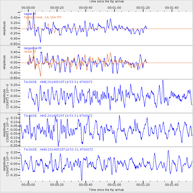
O03E Paynes Creek, CA, USA - Earthquake Result Viewer
*The percent match for this event was below the threshold and hence no stack was calculated.
| Earthquake location: |
Azores Islands Region |
| Earthquake latitude/longitude: |
42.1/-29.3 |
| Earthquake time(UTC): |
2014/05/26 (146) 19:43:14 GMT |
| Earthquake Depth: |
7.1 km |
| Earthquake Magnitude: |
5.0 MW |
| Earthquake Catalog/Contributor: |
ISC/ISC |
|
| Network: |
TA USArray Transportable Network (new EarthScope stations) |
| Station: |
O03E Paynes Creek, CA, USA |
| Lat/Lon: |
40.29 N/121.80 W |
| Elevation: |
967 m |
|
| Distance: |
66.1 deg |
| Az: |
303.315 deg |
| Baz: |
54.42 deg |
| Ray Param: |
$rayparam |
*The percent match for this event was below the threshold and hence was not used in the summary stack. |
|
| Radial Match: |
47.639538 % |
| Radial Bump: |
400 |
| Transverse Match: |
52.834454 % |
| Transverse Bump: |
400 |
| SOD ConfigId: |
3390531 |
| Insert Time: |
2019-04-12 01:22:29.781 +0000 |
| GWidth: |
2.5 |
| Max Bumps: |
400 |
| Tol: |
0.001 |
|
Signal To Noise
| Channel | StoN | STA | LTA |
| TA:O03E: :HHZ:20140526T19:53:31.470007Z | 1.2963891 | 6.589635E-8 | 5.083069E-8 |
| TA:O03E: :HHN:20140526T19:53:31.470007Z | 1.399654 | 9.6074416E-8 | 6.864154E-8 |
| TA:O03E: :HHE:20140526T19:53:31.470007Z | 1.1244715 | 1.0526512E-7 | 9.3612975E-8 |
| Arrivals |
| Ps | |
| PpPs | |
| PsPs/PpSs | |


