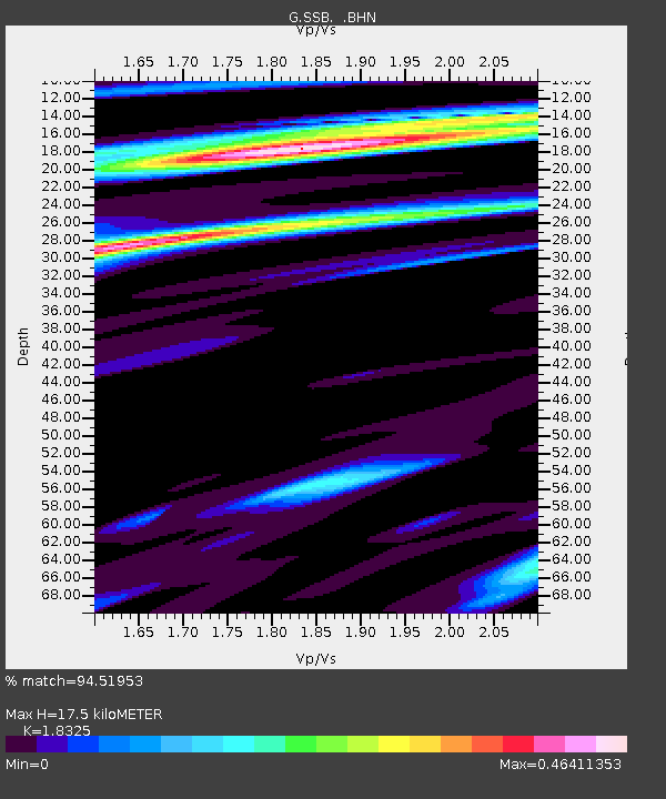
SSB Saint Sauveur Badole, France - Earthquake Result Viewer
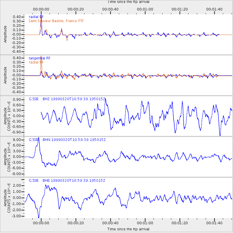
Earthquake location: Andreanof Islands, Aleutian Is.
Earthquake latitude/longitude: 51.6/-177.7
Earthquake time(UTC): 1999/03/20 (079) 10:47:45 GMT
Earthquake Depth: 33 km
Earthquake Magnitude: 6.3 MB, 6.8 MS, 6.9 MW, 6.8 ME
Earthquake Catalog/Contributor: WHDF/NEIC
Network: G GEOSCOPE
Station: SSB Saint Sauveur Badole, France
Lat/Lon: 45.28 N/4.54 E
Elevation: 700 m
Distance: 83.5 deg
Az: 358.43 deg
Baz: 1.388 deg
Ray Param: 0.04610345
Estimated Moho Depth: 17.5 km
Estimated Crust Vp/Vs: 1.83
Assumed Crust Vp: 6.1 km/s
Estimated Crust Vs: 3.329 km/s
Estimated Crust Poisson's Ratio: 0.29
Radial Match: 94.51953 %
Radial Bump: 303
Transverse Match: 78.655556 %
Transverse Bump: 400
SOD ConfigId: 4480
Insert Time: 2010-02-27 00:13:21.755 +0000
GWidth: 2.5
Max Bumps: 400
Tol: 0.001

Signal To Noise

ChannelStoNSTALTA
G:SSB: :BHN:19990320T10:59:39.195015Z9.1317963.5041824E-63.837342E-7
G:SSB: :BHE:19990320T10:59:39.195015Z4.54173331.5330883E-63.3755578E-7
G:SSB: :BHZ:19990320T10:59:39.195015Z1.40358613.357079E-72.3917872E-7
Arrivals
Ps2.4 SECOND
PpPs7.9 SECOND
PsPs/PpSs10 SECOND