You are here: Home > Network List > TA - USArray Transportable Network (new EarthScope stations) Stations List
> Station R56A Bull Pasture Mountain, McDowell, VA, USA > Earthquake Result Viewer
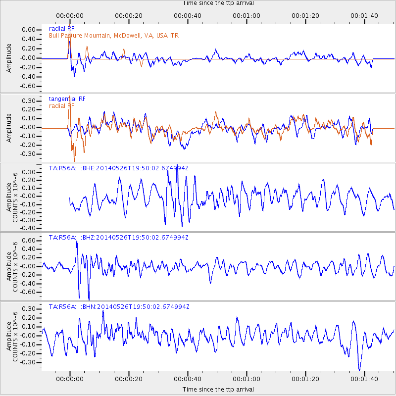
R56A Bull Pasture Mountain, McDowell, VA, USA - Earthquake Result Viewer
*The percent match for this event was below the threshold and hence no stack was calculated.
| Earthquake location: |
Azores Islands Region |
| Earthquake latitude/longitude: |
42.1/-29.3 |
| Earthquake time(UTC): |
2014/05/26 (146) 19:43:14 GMT |
| Earthquake Depth: |
7.1 km |
| Earthquake Magnitude: |
5.0 MW |
| Earthquake Catalog/Contributor: |
ISC/ISC |
|
| Network: |
TA USArray Transportable Network (new EarthScope stations) |
| Station: |
R56A Bull Pasture Mountain, McDowell, VA, USA |
| Lat/Lon: |
38.41 N/79.40 W |
| Elevation: |
902 m |
|
| Distance: |
38.0 deg |
| Az: |
281.651 deg |
| Baz: |
68.123 deg |
| Ray Param: |
$rayparam |
*The percent match for this event was below the threshold and hence was not used in the summary stack. |
|
| Radial Match: |
58.580616 % |
| Radial Bump: |
400 |
| Transverse Match: |
33.337605 % |
| Transverse Bump: |
400 |
| SOD ConfigId: |
3390531 |
| Insert Time: |
2019-04-12 01:22:49.793 +0000 |
| GWidth: |
2.5 |
| Max Bumps: |
400 |
| Tol: |
0.001 |
|
Signal To Noise
| Channel | StoN | STA | LTA |
| TA:R56A: :BHZ:20140526T19:50:02.674994Z | 4.1025105 | 2.8170018E-7 | 6.8665315E-8 |
| TA:R56A: :BHN:20140526T19:50:02.674994Z | 1.4116665 | 1.0940002E-7 | 7.749707E-8 |
| TA:R56A: :BHE:20140526T19:50:02.674994Z | 1.4480497 | 1.6432038E-7 | 1.13477036E-7 |
| Arrivals |
| Ps | |
| PpPs | |
| PsPs/PpSs | |


