You are here: Home > Network List > CI - Caltech Regional Seismic Network Stations List
> Station EDW2 EDW2, Mojave, CA, USA > Earthquake Result Viewer
EDW2 EDW2, Mojave, CA, USA - Earthquake Result Viewer
| Earthquake location: |
Vanuatu Islands |
| Earthquake latitude/longitude: |
-14.7/167.3 |
| Earthquake time(UTC): |
2012/07/06 (188) 02:28:22 GMT |
| Earthquake Depth: |
160 km |
| Earthquake Magnitude: |
5.7 MB, 6.3 MW, 6.3 MW |
| Earthquake Catalog/Contributor: |
WHDF/NEIC |
|
| Network: |
CI Caltech Regional Seismic Network |
| Station: |
EDW2 EDW2, Mojave, CA, USA |
| Lat/Lon: |
34.88 N/117.99 W |
| Elevation: |
772 m |
|
| Distance: |
86.1 deg |
| Az: |
52.624 deg |
| Baz: |
249.315 deg |
| Ray Param: |
0.04390004 |
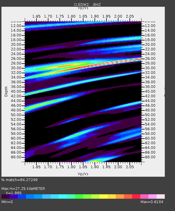
| Estimated Moho Depth: |
27.25 km |
| Estimated Crust Vp/Vs: |
2.00 |
| Assumed Crust Vp: |
6.276 km/s |
| Estimated Crust Vs: |
3.146 km/s |
| Estimated Crust Poisson's Ratio: |
0.33 |
|
| Radial Match: |
94.27249 % |
| Radial Bump: |
261 |
| Transverse Match: |
88.47772 % |
| Transverse Bump: |
354 |
| SOD ConfigId: |
463687 |
| Insert Time: |
2013-02-20 19:20:23.248 +0000 |
| GWidth: |
2.5 |
| Max Bumps: |
400 |
| Tol: |
0.001 |
|
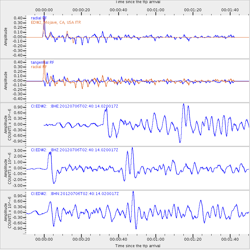
Signal To Noise
| Channel | StoN | STA | LTA |
| CI:EDW2: :BHZ:20120706T02:40:14.020017Z | 9.853591 | 1.5171764E-6 | 1.5397192E-7 |
| CI:EDW2: :BHN:20120706T02:40:14.020017Z | 3.5889957 | 3.0566196E-7 | 8.5166434E-8 |
| CI:EDW2: :BHE:20120706T02:40:14.020017Z | 6.441239 | 4.4065007E-7 | 6.841076E-8 |
| Arrivals |
| Ps | 4.4 SECOND |
| PpPs | 13 SECOND |
| PsPs/PpSs | 17 SECOND |


