You are here: Home > Network List > CI - Caltech Regional Seismic Network Stations List
> Station GMR Granite Mountains Research Center > Earthquake Result Viewer
GMR Granite Mountains Research Center - Earthquake Result Viewer
| Earthquake location: |
Vanuatu Islands |
| Earthquake latitude/longitude: |
-14.7/167.3 |
| Earthquake time(UTC): |
2012/07/06 (188) 02:28:22 GMT |
| Earthquake Depth: |
160 km |
| Earthquake Magnitude: |
5.7 MB, 6.3 MW, 6.3 MW |
| Earthquake Catalog/Contributor: |
WHDF/NEIC |
|
| Network: |
CI Caltech Regional Seismic Network |
| Station: |
GMR Granite Mountains Research Center |
| Lat/Lon: |
34.78 N/115.66 W |
| Elevation: |
1326 m |
|
| Distance: |
87.9 deg |
| Az: |
53.372 deg |
| Baz: |
250.681 deg |
| Ray Param: |
0.042613823 |
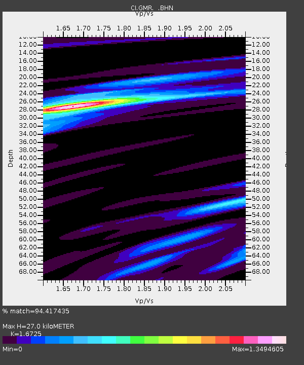
| Estimated Moho Depth: |
27.0 km |
| Estimated Crust Vp/Vs: |
1.67 |
| Assumed Crust Vp: |
6.276 km/s |
| Estimated Crust Vs: |
3.752 km/s |
| Estimated Crust Poisson's Ratio: |
0.22 |
|
| Radial Match: |
94.417435 % |
| Radial Bump: |
262 |
| Transverse Match: |
84.6065 % |
| Transverse Bump: |
364 |
| SOD ConfigId: |
463687 |
| Insert Time: |
2013-02-20 19:20:34.067 +0000 |
| GWidth: |
2.5 |
| Max Bumps: |
400 |
| Tol: |
0.001 |
|
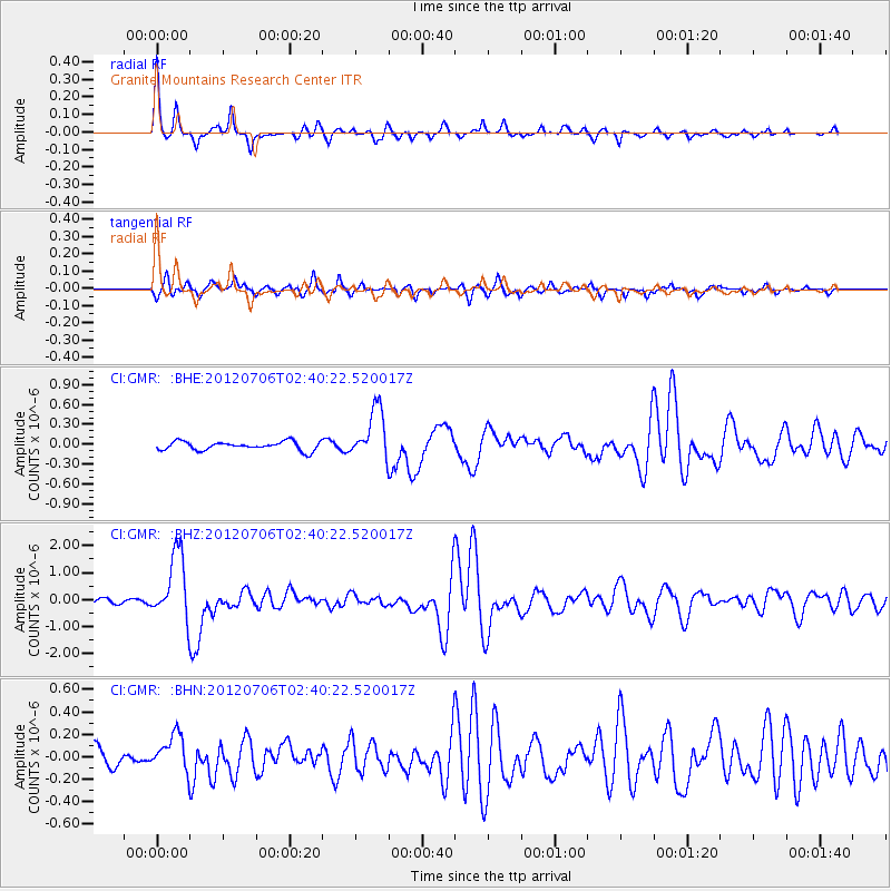
Signal To Noise
| Channel | StoN | STA | LTA |
| CI:GMR: :BHZ:20120706T02:40:22.520017Z | 10.532731 | 1.2342682E-6 | 1.1718407E-7 |
| CI:GMR: :BHN:20120706T02:40:22.520017Z | 1.8834221 | 1.61271E-7 | 8.562658E-8 |
| CI:GMR: :BHE:20120706T02:40:22.520017Z | 5.847333 | 3.8373872E-7 | 6.562628E-8 |
| Arrivals |
| Ps | 3.0 SECOND |
| PpPs | 11 SECOND |
| PsPs/PpSs | 14 SECOND |


