You are here: Home > Network List > IC - New China Digital Seismograph Network Stations List
> Station ENH Enshi, Hubei Province, China > Earthquake Result Viewer
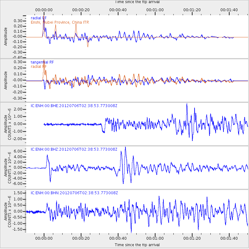
ENH Enshi, Hubei Province, China - Earthquake Result Viewer
| Earthquake location: |
Vanuatu Islands |
| Earthquake latitude/longitude: |
-14.7/167.3 |
| Earthquake time(UTC): |
2012/07/06 (188) 02:28:22 GMT |
| Earthquake Depth: |
160 km |
| Earthquake Magnitude: |
5.7 MB, 6.3 MW, 6.3 MW |
| Earthquake Catalog/Contributor: |
WHDF/NEIC |
|
| Network: |
IC New China Digital Seismograph Network |
| Station: |
ENH Enshi, Hubei Province, China |
| Lat/Lon: |
30.28 N/109.49 E |
| Elevation: |
500 m |
|
| Distance: |
71.4 deg |
| Az: |
309.386 deg |
| Baz: |
120.148 deg |
| Ray Param: |
0.05394402 |
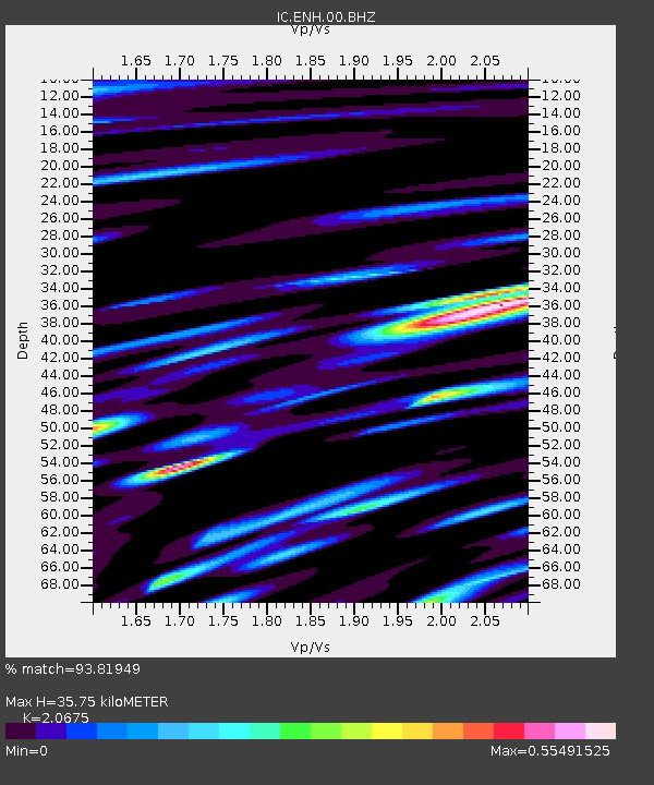
| Estimated Moho Depth: |
35.75 km |
| Estimated Crust Vp/Vs: |
2.07 |
| Assumed Crust Vp: |
6.083 km/s |
| Estimated Crust Vs: |
2.942 km/s |
| Estimated Crust Poisson's Ratio: |
0.35 |
|
| Radial Match: |
93.81949 % |
| Radial Bump: |
400 |
| Transverse Match: |
90.56045 % |
| Transverse Bump: |
400 |
| SOD ConfigId: |
463687 |
| Insert Time: |
2013-02-20 19:21:38.258 +0000 |
| GWidth: |
2.5 |
| Max Bumps: |
400 |
| Tol: |
0.001 |
|
Signal To Noise
| Channel | StoN | STA | LTA |
| IC:ENH:00:BHZ:20120706T02:38:53.773008Z | 34.558952 | 2.2257148E-6 | 6.440342E-8 |
| IC:ENH:00:BHN:20120706T02:38:53.773008Z | 5.2297397 | 3.1769036E-7 | 6.074688E-8 |
| IC:ENH:00:BHE:20120706T02:38:53.773008Z | 11.536418 | 5.967472E-7 | 5.1727255E-8 |
| Arrivals |
| Ps | 6.4 SECOND |
| PpPs | 18 SECOND |
| PsPs/PpSs | 24 SECOND |


