You are here: Home > Network List > G - GEOSCOPE Stations List
> Station SSB Saint Sauveur Badole, France > Earthquake Result Viewer
SSB Saint Sauveur Badole, France - Earthquake Result Viewer

| Earthquake location: |
Hokkaido, Japan Region |
| Earthquake latitude/longitude: |
41.0/142.3 |
| Earthquake time(UTC): |
2001/08/13 (225) 20:11:23 GMT |
| Earthquake Depth: |
38 km |
| Earthquake Magnitude: |
6.0 MB, 6.3 MS, 6.4 MW, 6.3 ME |
| Earthquake Catalog/Contributor: |
WHDF/NEIC |
|
| Network: |
G GEOSCOPE |
| Station: |
SSB Saint Sauveur Badole, France |
| Lat/Lon: |
45.28 N/4.54 E |
| Elevation: |
700 m |
|
| Distance: |
86.1 deg |
| Az: |
331.597 deg |
| Baz: |
30.635 deg |
| Ray Param: |
0.04423226 |
| Estimated Moho Depth: |
27.5 km |
| Estimated Crust Vp/Vs: |
1.64 |
| Assumed Crust Vp: |
6.1 km/s |
| Estimated Crust Vs: |
3.714 km/s |
| Estimated Crust Poisson's Ratio: |
0.21 |
|
| Radial Match: |
95.720375 % |
| Radial Bump: |
400 |
| Transverse Match: |
85.81268 % |
| Transverse Bump: |
400 |
| SOD ConfigId: |
20082 |
| Insert Time: |
2010-02-27 00:13:38.363 +0000 |
| GWidth: |
2.5 |
| Max Bumps: |
400 |
| Tol: |
0.001 |
|
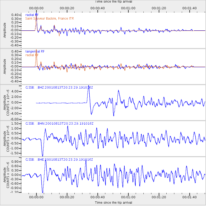
Signal To Noise
| Channel | StoN | STA | LTA |
| G:SSB: :BHN:20010813T20:23:29.191016Z | 11.20039 | 6.894858E-7 | 6.1559085E-8 |
| G:SSB: :BHE:20010813T20:23:29.191016Z | 10.474364 | 4.7708954E-7 | 4.554831E-8 |
| G:SSB: :BHZ:20010813T20:23:29.191016Z | 50.539185 | 2.447132E-6 | 4.842049E-8 |
| Arrivals |
| Ps | 3.0 SECOND |
| PpPs | 12 SECOND |
| PsPs/PpSs | 15 SECOND |


