You are here: Home > Network List > TA - USArray Transportable Network (new EarthScope stations) Stations List
> Station I05D Terrebonne, OR, USA > Earthquake Result Viewer
I05D Terrebonne, OR, USA - Earthquake Result Viewer
| Earthquake location: |
Vanuatu Islands |
| Earthquake latitude/longitude: |
-14.7/167.3 |
| Earthquake time(UTC): |
2012/07/06 (188) 02:28:22 GMT |
| Earthquake Depth: |
160 km |
| Earthquake Magnitude: |
5.7 MB, 6.3 MW, 6.3 MW |
| Earthquake Catalog/Contributor: |
WHDF/NEIC |
|
| Network: |
TA USArray Transportable Network (new EarthScope stations) |
| Station: |
I05D Terrebonne, OR, USA |
| Lat/Lon: |
44.34 N/121.34 W |
| Elevation: |
1546 m |
|
| Distance: |
87.3 deg |
| Az: |
42.885 deg |
| Baz: |
246.623 deg |
| Ray Param: |
0.043073855 |
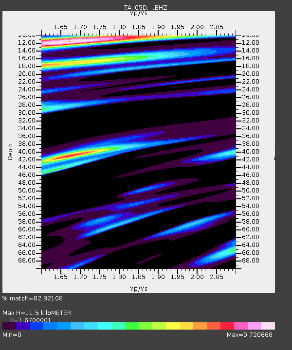
| Estimated Moho Depth: |
11.5 km |
| Estimated Crust Vp/Vs: |
1.67 |
| Assumed Crust Vp: |
6.597 km/s |
| Estimated Crust Vs: |
3.951 km/s |
| Estimated Crust Poisson's Ratio: |
0.22 |
|
| Radial Match: |
82.82108 % |
| Radial Bump: |
357 |
| Transverse Match: |
68.45259 % |
| Transverse Bump: |
345 |
| SOD ConfigId: |
463687 |
| Insert Time: |
2013-02-20 19:26:21.531 +0000 |
| GWidth: |
2.5 |
| Max Bumps: |
400 |
| Tol: |
0.001 |
|
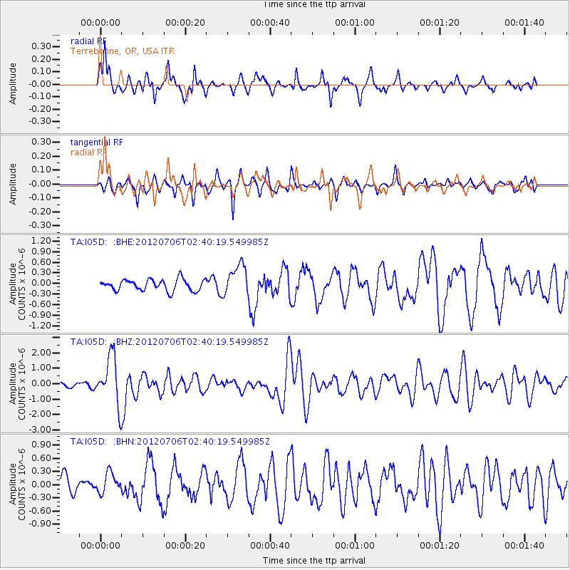
Signal To Noise
| Channel | StoN | STA | LTA |
| TA:I05D: :BHZ:20120706T02:40:19.549985Z | 9.4599285 | 1.628498E-6 | 1.7214695E-7 |
| TA:I05D: :BHN:20120706T02:40:19.549985Z | 1.4404273 | 2.339652E-7 | 1.6242763E-7 |
| TA:I05D: :BHE:20120706T02:40:19.549985Z | 2.7958503 | 4.470769E-7 | 1.599073E-7 |
| Arrivals |
| Ps | 1.2 SECOND |
| PpPs | 4.5 SECOND |
| PsPs/PpSs | 5.7 SECOND |


