You are here: Home > Network List > TA - USArray Transportable Network (new EarthScope stations) Stations List
> Station G05D Wamic, OR, USA > Earthquake Result Viewer
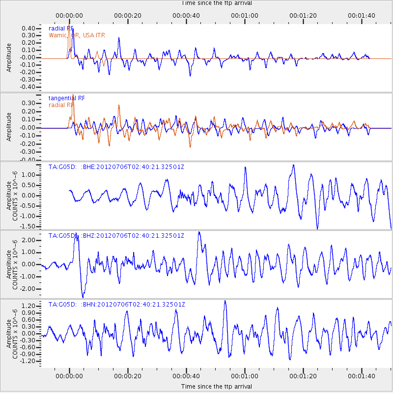
G05D Wamic, OR, USA - Earthquake Result Viewer
*The percent match for this event was below the threshold and hence no stack was calculated.
| Earthquake location: |
Vanuatu Islands |
| Earthquake latitude/longitude: |
-14.7/167.3 |
| Earthquake time(UTC): |
2012/07/06 (188) 02:28:22 GMT |
| Earthquake Depth: |
160 km |
| Earthquake Magnitude: |
5.7 MB, 6.3 MW, 6.3 MW |
| Earthquake Catalog/Contributor: |
WHDF/NEIC |
|
| Network: |
TA USArray Transportable Network (new EarthScope stations) |
| Station: |
G05D Wamic, OR, USA |
| Lat/Lon: |
45.24 N/121.32 W |
| Elevation: |
592 m |
|
| Distance: |
87.7 deg |
| Az: |
42.061 deg |
| Baz: |
246.603 deg |
| Ray Param: |
$rayparam |
*The percent match for this event was below the threshold and hence was not used in the summary stack. |
|
| Radial Match: |
69.195595 % |
| Radial Bump: |
340 |
| Transverse Match: |
60.48196 % |
| Transverse Bump: |
400 |
| SOD ConfigId: |
463687 |
| Insert Time: |
2013-02-20 19:26:23.653 +0000 |
| GWidth: |
2.5 |
| Max Bumps: |
400 |
| Tol: |
0.001 |
|
Signal To Noise
| Channel | StoN | STA | LTA |
| TA:G05D: :BHZ:20120706T02:40:21.32501Z | 7.584084 | 1.5503167E-6 | 2.0441715E-7 |
| TA:G05D: :BHN:20120706T02:40:21.32501Z | 1.2616143 | 2.2116768E-7 | 1.753053E-7 |
| TA:G05D: :BHE:20120706T02:40:21.32501Z | 1.6850935 | 4.1185672E-7 | 2.4441178E-7 |
| Arrivals |
| Ps | |
| PpPs | |
| PsPs/PpSs | |


