You are here: Home > Network List > TA - USArray Transportable Network (new EarthScope stations) Stations List
> Station TPFO Pinon Flats, CA, USA > Earthquake Result Viewer
TPFO Pinon Flats, CA, USA - Earthquake Result Viewer
| Earthquake location: |
Vanuatu Islands |
| Earthquake latitude/longitude: |
-14.7/167.3 |
| Earthquake time(UTC): |
2012/07/06 (188) 02:28:22 GMT |
| Earthquake Depth: |
160 km |
| Earthquake Magnitude: |
5.7 MB, 6.3 MW, 6.3 MW |
| Earthquake Catalog/Contributor: |
WHDF/NEIC |
|
| Network: |
TA USArray Transportable Network (new EarthScope stations) |
| Station: |
TPFO Pinon Flats, CA, USA |
| Lat/Lon: |
33.61 N/116.45 W |
| Elevation: |
1275 m |
|
| Distance: |
86.9 deg |
| Az: |
54.261 deg |
| Baz: |
250.277 deg |
| Ray Param: |
0.04335387 |
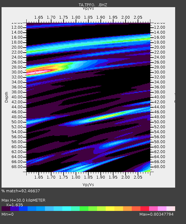
| Estimated Moho Depth: |
30.0 km |
| Estimated Crust Vp/Vs: |
1.63 |
| Assumed Crust Vp: |
6.264 km/s |
| Estimated Crust Vs: |
3.831 km/s |
| Estimated Crust Poisson's Ratio: |
0.20 |
|
| Radial Match: |
92.46637 % |
| Radial Bump: |
275 |
| Transverse Match: |
85.55729 % |
| Transverse Bump: |
385 |
| SOD ConfigId: |
463687 |
| Insert Time: |
2013-02-20 19:26:58.401 +0000 |
| GWidth: |
2.5 |
| Max Bumps: |
400 |
| Tol: |
0.001 |
|
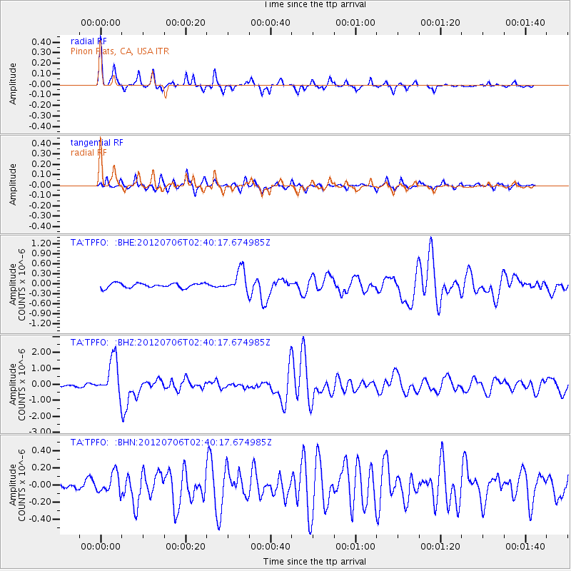
Signal To Noise
| Channel | StoN | STA | LTA |
| TA:TPFO: :BHZ:20120706T02:40:17.674985Z | 14.917579 | 1.1973867E-6 | 8.026682E-8 |
| TA:TPFO: :BHN:20120706T02:40:17.674985Z | 2.0595877 | 1.1996669E-7 | 5.8247913E-8 |
| TA:TPFO: :BHE:20120706T02:40:17.674985Z | 5.0070148 | 3.4652572E-7 | 6.920805E-8 |
| Arrivals |
| Ps | 3.1 SECOND |
| PpPs | 12 SECOND |
| PsPs/PpSs | 15 SECOND |


