You are here: Home > Network List > TA - USArray Transportable Network (new EarthScope stations) Stations List
> Station K02D Willamette Meridian, OR, USA > Earthquake Result Viewer
K02D Willamette Meridian, OR, USA - Earthquake Result Viewer
| Earthquake location: |
Vanuatu Islands |
| Earthquake latitude/longitude: |
-14.7/167.3 |
| Earthquake time(UTC): |
2012/07/06 (188) 02:28:22 GMT |
| Earthquake Depth: |
160 km |
| Earthquake Magnitude: |
5.7 MB, 6.3 MW, 6.3 MW |
| Earthquake Catalog/Contributor: |
WHDF/NEIC |
|
| Network: |
TA USArray Transportable Network (new EarthScope stations) |
| Station: |
K02D Willamette Meridian, OR, USA |
| Lat/Lon: |
42.70 N/123.67 W |
| Elevation: |
989 m |
|
| Distance: |
85.1 deg |
| Az: |
43.693 deg |
| Baz: |
245.081 deg |
| Ray Param: |
0.044657134 |
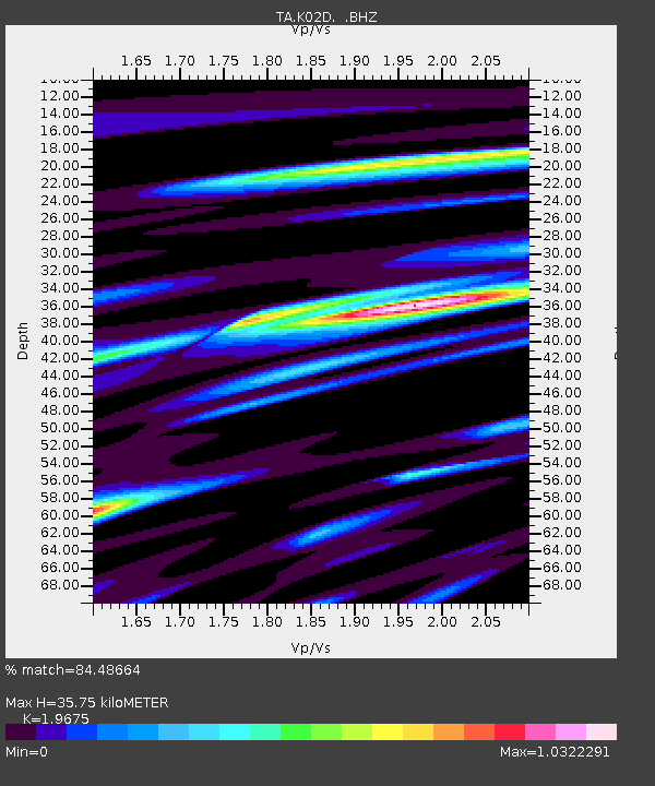
| Estimated Moho Depth: |
35.75 km |
| Estimated Crust Vp/Vs: |
1.97 |
| Assumed Crust Vp: |
6.522 km/s |
| Estimated Crust Vs: |
3.315 km/s |
| Estimated Crust Poisson's Ratio: |
0.33 |
|
| Radial Match: |
84.48664 % |
| Radial Bump: |
400 |
| Transverse Match: |
76.46042 % |
| Transverse Bump: |
400 |
| SOD ConfigId: |
463687 |
| Insert Time: |
2013-02-20 19:27:15.651 +0000 |
| GWidth: |
2.5 |
| Max Bumps: |
400 |
| Tol: |
0.001 |
|
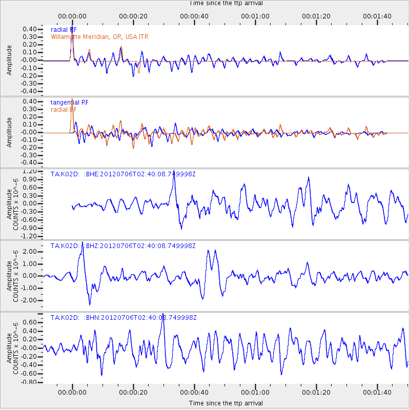
Signal To Noise
| Channel | StoN | STA | LTA |
| TA:K02D: :BHZ:20120706T02:40:08.749998Z | 8.184255 | 1.203208E-6 | 1.4701497E-7 |
| TA:K02D: :BHN:20120706T02:40:08.749998Z | 1.1400136 | 1.4012318E-7 | 1.229136E-7 |
| TA:K02D: :BHE:20120706T02:40:08.749998Z | 3.3366408 | 4.53199E-7 | 1.3582493E-7 |
| Arrivals |
| Ps | 5.4 SECOND |
| PpPs | 16 SECOND |
| PsPs/PpSs | 21 SECOND |


