You are here: Home > Network List > TA - USArray Transportable Network (new EarthScope stations) Stations List
> Station F05D White Salmon, WA, USA > Earthquake Result Viewer
F05D White Salmon, WA, USA - Earthquake Result Viewer

| Earthquake location: |
Vanuatu Islands |
| Earthquake latitude/longitude: |
-14.7/167.3 |
| Earthquake time(UTC): |
2012/07/06 (188) 02:28:22 GMT |
| Earthquake Depth: |
160 km |
| Earthquake Magnitude: |
5.7 MB, 6.3 MW, 6.3 MW |
| Earthquake Catalog/Contributor: |
WHDF/NEIC |
|
| Network: |
TA USArray Transportable Network (new EarthScope stations) |
| Station: |
F05D White Salmon, WA, USA |
| Lat/Lon: |
45.89 N/121.46 W |
| Elevation: |
472 m |
|
| Distance: |
87.8 deg |
| Az: |
41.431 deg |
| Baz: |
246.476 deg |
| Ray Param: |
0.04267818 |
| Estimated Moho Depth: |
36.25 km |
| Estimated Crust Vp/Vs: |
1.60 |
| Assumed Crust Vp: |
6.597 km/s |
| Estimated Crust Vs: |
4.123 km/s |
| Estimated Crust Poisson's Ratio: |
0.18 |
|
| Radial Match: |
82.549034 % |
| Radial Bump: |
400 |
| Transverse Match: |
65.79723 % |
| Transverse Bump: |
400 |
| SOD ConfigId: |
463687 |
| Insert Time: |
2013-02-20 19:27:40.765 +0000 |
| GWidth: |
2.5 |
| Max Bumps: |
400 |
| Tol: |
0.001 |
|
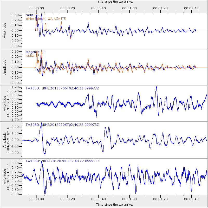
Signal To Noise
| Channel | StoN | STA | LTA |
| TA:F05D: :BHZ:20120706T02:40:22.099973Z | 12.620907 | 1.297571E-6 | 1.02811235E-7 |
| TA:F05D: :BHN:20120706T02:40:22.099973Z | 4.8176026 | 3.4602584E-7 | 7.182532E-8 |
| TA:F05D: :BHE:20120706T02:40:22.099973Z | 3.427119 | 3.5792274E-7 | 1.0443837E-7 |
| Arrivals |
| Ps | 3.4 SECOND |
| PpPs | 14 SECOND |
| PsPs/PpSs | 17 SECOND |


