You are here: Home > Network List > TA - USArray Transportable Network (new EarthScope stations) Stations List
> Station C06D Leavenworth, WQ, USA > Earthquake Result Viewer
C06D Leavenworth, WQ, USA - Earthquake Result Viewer
| Earthquake location: |
Vanuatu Islands |
| Earthquake latitude/longitude: |
-14.7/167.3 |
| Earthquake time(UTC): |
2012/07/06 (188) 02:28:22 GMT |
| Earthquake Depth: |
160 km |
| Earthquake Magnitude: |
5.7 MB, 6.3 MW, 6.3 MW |
| Earthquake Catalog/Contributor: |
WHDF/NEIC |
|
| Network: |
TA USArray Transportable Network (new EarthScope stations) |
| Station: |
C06D Leavenworth, WQ, USA |
| Lat/Lon: |
47.92 N/120.89 W |
| Elevation: |
544 m |
|
| Distance: |
89.0 deg |
| Az: |
39.712 deg |
| Baz: |
246.84 deg |
| Ray Param: |
0.04182851 |
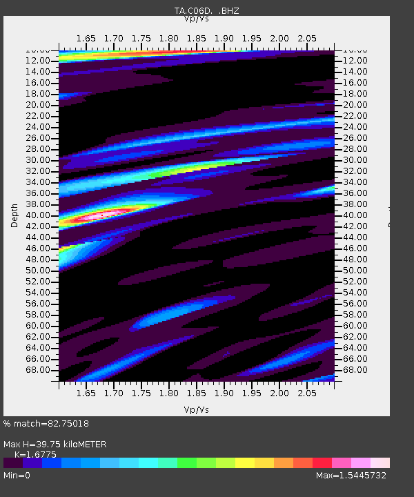
| Estimated Moho Depth: |
39.75 km |
| Estimated Crust Vp/Vs: |
1.68 |
| Assumed Crust Vp: |
6.597 km/s |
| Estimated Crust Vs: |
3.933 km/s |
| Estimated Crust Poisson's Ratio: |
0.22 |
|
| Radial Match: |
82.75018 % |
| Radial Bump: |
400 |
| Transverse Match: |
64.66394 % |
| Transverse Bump: |
400 |
| SOD ConfigId: |
463687 |
| Insert Time: |
2013-02-20 19:28:19.408 +0000 |
| GWidth: |
2.5 |
| Max Bumps: |
400 |
| Tol: |
0.001 |
|

Signal To Noise
| Channel | StoN | STA | LTA |
| TA:C06D: :BHZ:20120706T02:40:27.57501Z | 4.641057 | 8.8930494E-7 | 1.916169E-7 |
| TA:C06D: :BHN:20120706T02:40:27.57501Z | 0.8756858 | 3.462086E-7 | 3.9535706E-7 |
| TA:C06D: :BHE:20120706T02:40:27.57501Z | 1.2371349 | 4.560133E-7 | 3.6860436E-7 |
| Arrivals |
| Ps | 4.2 SECOND |
| PpPs | 16 SECOND |
| PsPs/PpSs | 20 SECOND |


