You are here: Home > Network List > TA - USArray Transportable Network (new EarthScope stations) Stations List
> Station TOLK Toolik Lake Research Station, AK, USA > Earthquake Result Viewer
TOLK Toolik Lake Research Station, AK, USA - Earthquake Result Viewer

| Earthquake location: |
Vanuatu Islands |
| Earthquake latitude/longitude: |
-14.7/167.3 |
| Earthquake time(UTC): |
2012/07/06 (188) 02:28:22 GMT |
| Earthquake Depth: |
160 km |
| Earthquake Magnitude: |
5.7 MB, 6.3 MW, 6.3 MW |
| Earthquake Catalog/Contributor: |
WHDF/NEIC |
|
| Network: |
TA USArray Transportable Network (new EarthScope stations) |
| Station: |
TOLK Toolik Lake Research Station, AK, USA |
| Lat/Lon: |
68.64 N/149.57 W |
| Elevation: |
760 m |
|
| Distance: |
88.6 deg |
| Az: |
14.497 deg |
| Baz: |
221.405 deg |
| Ray Param: |
0.04213279 |
| Estimated Moho Depth: |
11.75 km |
| Estimated Crust Vp/Vs: |
2.05 |
| Assumed Crust Vp: |
6.316 km/s |
| Estimated Crust Vs: |
3.085 km/s |
| Estimated Crust Poisson's Ratio: |
0.34 |
|
| Radial Match: |
92.82838 % |
| Radial Bump: |
381 |
| Transverse Match: |
87.78131 % |
| Transverse Bump: |
400 |
| SOD ConfigId: |
463687 |
| Insert Time: |
2013-02-20 19:28:32.466 +0000 |
| GWidth: |
2.5 |
| Max Bumps: |
400 |
| Tol: |
0.001 |
|
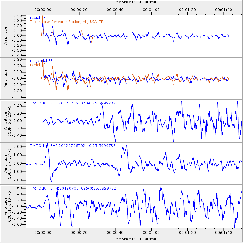
Signal To Noise
| Channel | StoN | STA | LTA |
| TA:TOLK: :BHZ:20120706T02:40:25.599973Z | 17.87223 | 1.3402728E-6 | 7.499191E-8 |
| TA:TOLK: :BHN:20120706T02:40:25.599973Z | 6.1975493 | 2.2447368E-7 | 3.621975E-8 |
| TA:TOLK: :BHE:20120706T02:40:25.599973Z | 4.868244 | 2.2274206E-7 | 4.5754085E-8 |
| Arrivals |
| Ps | 2.0 SECOND |
| PpPs | 5.6 SECOND |
| PsPs/PpSs | 7.6 SECOND |


