You are here: Home > Network List > UW - Pacific Northwest Regional Seismic Network Stations List
> Station HOOD Mt Hood Meadows, OR CREST BB SMO > Earthquake Result Viewer
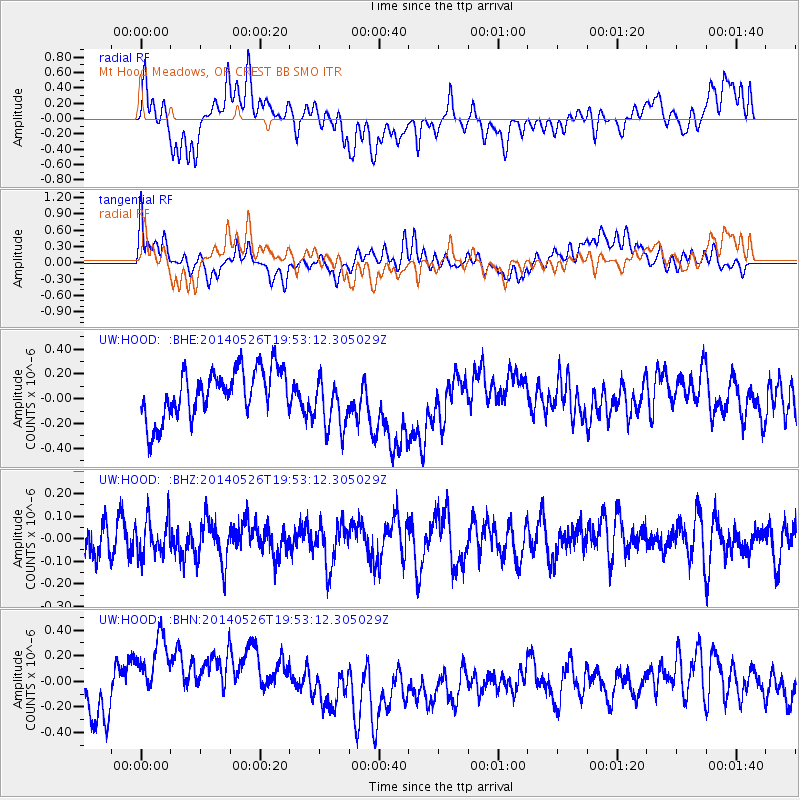
HOOD Mt Hood Meadows, OR CREST BB SMO - Earthquake Result Viewer
*The percent match for this event was below the threshold and hence no stack was calculated.
| Earthquake location: |
Azores Islands Region |
| Earthquake latitude/longitude: |
42.1/-29.3 |
| Earthquake time(UTC): |
2014/05/26 (146) 19:43:14 GMT |
| Earthquake Depth: |
7.1 km |
| Earthquake Magnitude: |
5.0 MW |
| Earthquake Catalog/Contributor: |
ISC/ISC |
|
| Network: |
UW Pacific Northwest Regional Seismic Network |
| Station: |
HOOD Mt Hood Meadows, OR CREST BB SMO |
| Lat/Lon: |
45.32 N/121.65 W |
| Elevation: |
1520 m |
|
| Distance: |
63.2 deg |
| Az: |
307.824 deg |
| Baz: |
56.453 deg |
| Ray Param: |
$rayparam |
*The percent match for this event was below the threshold and hence was not used in the summary stack. |
|
| Radial Match: |
48.686592 % |
| Radial Bump: |
400 |
| Transverse Match: |
30.465645 % |
| Transverse Bump: |
400 |
| SOD ConfigId: |
3390531 |
| Insert Time: |
2019-04-12 01:24:19.754 +0000 |
| GWidth: |
2.5 |
| Max Bumps: |
400 |
| Tol: |
0.001 |
|
Signal To Noise
| Channel | StoN | STA | LTA |
| UW:HOOD: :BHZ:20140526T19:53:12.305029Z | 1.0447099 | 8.370676E-8 | 8.0124394E-8 |
| UW:HOOD: :BHN:20140526T19:53:12.305029Z | 2.702057 | 3.8864212E-7 | 1.4383197E-7 |
| UW:HOOD: :BHE:20140526T19:53:12.305029Z | 1.1202531 | 2.2062245E-7 | 1.9693982E-7 |
| Arrivals |
| Ps | |
| PpPs | |
| PsPs/PpSs | |


