You are here: Home > Network List > UW - Pacific Northwest Regional Seismic Network Stations List
> Station MRBL Marblemount, WA, USA > Earthquake Result Viewer
MRBL Marblemount, WA, USA - Earthquake Result Viewer
*The percent match for this event was below the threshold and hence no stack was calculated.
| Earthquake location: |
Vanuatu Islands |
| Earthquake latitude/longitude: |
-14.7/167.3 |
| Earthquake time(UTC): |
2012/07/06 (188) 02:28:22 GMT |
| Earthquake Depth: |
160 km |
| Earthquake Magnitude: |
5.7 MB, 6.3 MW, 6.3 MW |
| Earthquake Catalog/Contributor: |
WHDF/NEIC |
|
| Network: |
UW Pacific Northwest Regional Seismic Network |
| Station: |
MRBL Marblemount, WA, USA |
| Lat/Lon: |
48.52 N/121.48 W |
| Elevation: |
75 m |
|
| Distance: |
88.9 deg |
| Az: |
39.009 deg |
| Baz: |
246.388 deg |
| Ray Param: |
$rayparam |
*The percent match for this event was below the threshold and hence was not used in the summary stack. |
|
| Radial Match: |
79.91422 % |
| Radial Bump: |
400 |
| Transverse Match: |
73.76076 % |
| Transverse Bump: |
400 |
| SOD ConfigId: |
463687 |
| Insert Time: |
2013-02-20 19:30:40.701 +0000 |
| GWidth: |
2.5 |
| Max Bumps: |
400 |
| Tol: |
0.001 |
|
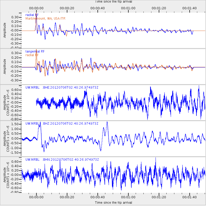
Signal To Noise
| Channel | StoN | STA | LTA |
| UW:MRBL: :BHZ:20120706T02:40:26.974973Z | 12.172654 | 8.900174E-7 | 7.3116134E-8 |
| UW:MRBL: :BHN:20120706T02:40:26.974973Z | 1.0014536 | 1.3723272E-7 | 1.3703352E-7 |
| UW:MRBL: :BHE:20120706T02:40:26.974973Z | 2.1636164 | 2.8419694E-7 | 1.3135273E-7 |
| Arrivals |
| Ps | |
| PpPs | |
| PsPs/PpSs | |


