You are here: Home > Network List > G - GEOSCOPE Stations List
> Station SSB Saint Sauveur Badole, France > Earthquake Result Viewer
SSB Saint Sauveur Badole, France - Earthquake Result Viewer
| Earthquake location: |
Southern Alaska |
| Earthquake latitude/longitude: |
59.0/-155.1 |
| Earthquake time(UTC): |
2001/07/28 (209) 07:32:43 GMT |
| Earthquake Depth: |
131 km |
| Earthquake Magnitude: |
5.7 MB, 5.7 MS, 6.6 MW, 6.2 ME |
| Earthquake Catalog/Contributor: |
WHDF/NEIC |
|
| Network: |
G GEOSCOPE |
| Station: |
SSB Saint Sauveur Badole, France |
| Lat/Lon: |
45.28 N/4.54 E |
| Elevation: |
700 m |
|
| Distance: |
74.7 deg |
| Az: |
14.74 deg |
| Baz: |
349.258 deg |
| Ray Param: |
0.05182995 |
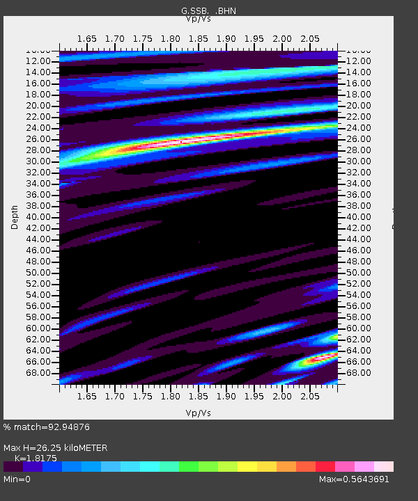
| Estimated Moho Depth: |
26.25 km |
| Estimated Crust Vp/Vs: |
1.82 |
| Assumed Crust Vp: |
6.1 km/s |
| Estimated Crust Vs: |
3.356 km/s |
| Estimated Crust Poisson's Ratio: |
0.28 |
|
| Radial Match: |
92.94876 % |
| Radial Bump: |
300 |
| Transverse Match: |
80.82415 % |
| Transverse Bump: |
400 |
| SOD ConfigId: |
4714 |
| Insert Time: |
2010-02-27 00:14:01.994 +0000 |
| GWidth: |
2.5 |
| Max Bumps: |
400 |
| Tol: |
0.001 |
|
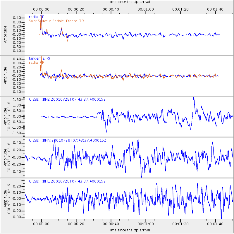
Signal To Noise
| Channel | StoN | STA | LTA |
| G:SSB: :BHN:20010728T07:43:37.400015Z | 3.1275597 | 7.492922E-8 | 2.3957726E-8 |
| G:SSB: :BHE:20010728T07:43:37.400015Z | 0.5666914 | 2.1407185E-8 | 3.7775738E-8 |
| G:SSB: :BHZ:20010728T07:43:37.400015Z | 6.71404 | 2.4255672E-7 | 3.6126792E-8 |
| Arrivals |
| Ps | 3.6 SECOND |
| PpPs | 12 SECOND |
| PsPs/PpSs | 15 SECOND |


