You are here: Home > Network List > G - GEOSCOPE Stations List
> Station SSB Saint Sauveur Badole, France > Earthquake Result Viewer
SSB Saint Sauveur Badole, France - Earthquake Result Viewer
| Earthquake location: |
Western Iran |
| Earthquake latitude/longitude: |
35.6/49.0 |
| Earthquake time(UTC): |
2002/06/22 (173) 02:58:21 GMT |
| Earthquake Depth: |
10 km |
| Earthquake Magnitude: |
6.2 MB, 6.4 MS, 6.5 MW, 6.5 MW |
| Earthquake Catalog/Contributor: |
WHDF/NEIC |
|
| Network: |
G GEOSCOPE |
| Station: |
SSB Saint Sauveur Badole, France |
| Lat/Lon: |
45.28 N/4.54 E |
| Elevation: |
700 m |
|
| Distance: |
34.8 deg |
| Az: |
299.93 deg |
| Baz: |
90.204 deg |
| Ray Param: |
0.077541545 |
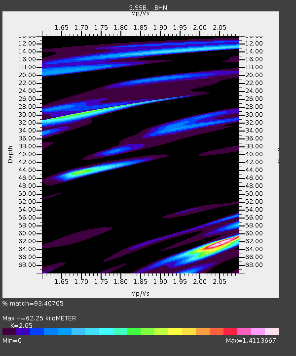
| Estimated Moho Depth: |
62.25 km |
| Estimated Crust Vp/Vs: |
2.05 |
| Assumed Crust Vp: |
6.1 km/s |
| Estimated Crust Vs: |
2.976 km/s |
| Estimated Crust Poisson's Ratio: |
0.34 |
|
| Radial Match: |
93.40705 % |
| Radial Bump: |
291 |
| Transverse Match: |
83.66466 % |
| Transverse Bump: |
400 |
| SOD ConfigId: |
20082 |
| Insert Time: |
2010-02-27 00:14:22.235 +0000 |
| GWidth: |
2.5 |
| Max Bumps: |
400 |
| Tol: |
0.001 |
|

Signal To Noise
| Channel | StoN | STA | LTA |
| G:SSB: :BHN:20020622T03:04:41.499005Z | 1.9287355 | 8.774592E-8 | 4.5494012E-8 |
| G:SSB: :BHE:20020622T03:04:41.496014Z | 23.391981 | 2.297156E-6 | 9.8202705E-8 |
| G:SSB: :BHZ:20020622T03:04:41.496014Z | 40.5341 | 2.670332E-6 | 6.587865E-8 |
| Arrivals |
| Ps | 11 SECOND |
| PpPs | 29 SECOND |
| PsPs/PpSs | 41 SECOND |


