You are here: Home > Network List > CI - Caltech Regional Seismic Network Stations List
> Station SMM Simmler, CA, USA > Earthquake Result Viewer
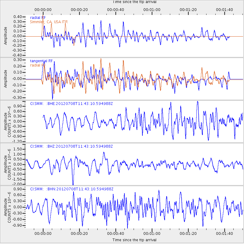
SMM Simmler, CA, USA - Earthquake Result Viewer
*The percent match for this event was below the threshold and hence no stack was calculated.
| Earthquake location: |
Kuril Islands |
| Earthquake latitude/longitude: |
45.5/151.3 |
| Earthquake time(UTC): |
2012/07/08 (190) 11:33:02 GMT |
| Earthquake Depth: |
20 km |
| Earthquake Magnitude: |
5.7 MB, 5.6 MS, 6.0 MW, 5.8 MW |
| Earthquake Catalog/Contributor: |
WHDF/NEIC |
|
| Network: |
CI Caltech Regional Seismic Network |
| Station: |
SMM Simmler, CA, USA |
| Lat/Lon: |
35.31 N/120.00 W |
| Elevation: |
599 m |
|
| Distance: |
65.0 deg |
| Az: |
64.4 deg |
| Baz: |
309.141 deg |
| Ray Param: |
$rayparam |
*The percent match for this event was below the threshold and hence was not used in the summary stack. |
|
| Radial Match: |
60.859943 % |
| Radial Bump: |
400 |
| Transverse Match: |
60.845753 % |
| Transverse Bump: |
400 |
| SOD ConfigId: |
463687 |
| Insert Time: |
2013-02-20 19:50:19.876 +0000 |
| GWidth: |
2.5 |
| Max Bumps: |
400 |
| Tol: |
0.001 |
|
Signal To Noise
| Channel | StoN | STA | LTA |
| CI:SMM: :BHZ:20120708T11:43:10.594988Z | 1.6134567 | 4.477693E-7 | 2.7752174E-7 |
| CI:SMM: :BHN:20120708T11:43:10.594988Z | 1.7587377 | 3.9750503E-7 | 2.2601724E-7 |
| CI:SMM: :BHE:20120708T11:43:10.594988Z | 0.733356 | 2.2118427E-7 | 3.0160558E-7 |
| Arrivals |
| Ps | |
| PpPs | |
| PsPs/PpSs | |


