You are here: Home > Network List > CI - Caltech Regional Seismic Network Stations List
> Station MPP McPhearson Peak > Earthquake Result Viewer
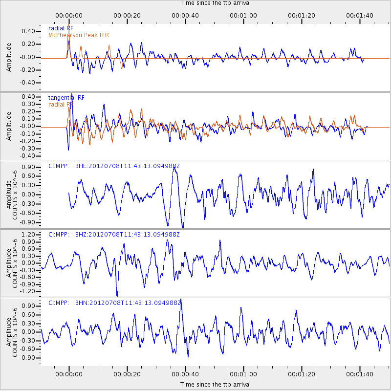
MPP McPhearson Peak - Earthquake Result Viewer
*The percent match for this event was below the threshold and hence no stack was calculated.
| Earthquake location: |
Kuril Islands |
| Earthquake latitude/longitude: |
45.5/151.3 |
| Earthquake time(UTC): |
2012/07/08 (190) 11:33:02 GMT |
| Earthquake Depth: |
20 km |
| Earthquake Magnitude: |
5.7 MB, 5.6 MS, 6.0 MW, 5.8 MW |
| Earthquake Catalog/Contributor: |
WHDF/NEIC |
|
| Network: |
CI Caltech Regional Seismic Network |
| Station: |
MPP McPhearson Peak |
| Lat/Lon: |
34.89 N/119.81 W |
| Elevation: |
1739 m |
|
| Distance: |
65.4 deg |
| Az: |
64.659 deg |
| Baz: |
309.354 deg |
| Ray Param: |
$rayparam |
*The percent match for this event was below the threshold and hence was not used in the summary stack. |
|
| Radial Match: |
37.553413 % |
| Radial Bump: |
400 |
| Transverse Match: |
58.632744 % |
| Transverse Bump: |
400 |
| SOD ConfigId: |
463687 |
| Insert Time: |
2013-02-20 19:50:32.809 +0000 |
| GWidth: |
2.5 |
| Max Bumps: |
400 |
| Tol: |
0.001 |
|
Signal To Noise
| Channel | StoN | STA | LTA |
| CI:MPP: :BHZ:20120708T11:43:13.094988Z | 1.1324223 | 3.064336E-7 | 2.706001E-7 |
| CI:MPP: :BHN:20120708T11:43:13.094988Z | 1.286394 | 2.9880024E-7 | 2.3227739E-7 |
| CI:MPP: :BHE:20120708T11:43:13.094988Z | 1.8248519 | 4.8498663E-7 | 2.6576765E-7 |
| Arrivals |
| Ps | |
| PpPs | |
| PsPs/PpSs | |


