You are here: Home > Network List > KR - Kyrgyz Digital Network Stations List
> Station BOOM Boom, Kyrgyzstan > Earthquake Result Viewer
BOOM Boom, Kyrgyzstan - Earthquake Result Viewer
| Earthquake location: |
Kuril Islands |
| Earthquake latitude/longitude: |
45.5/151.3 |
| Earthquake time(UTC): |
2012/07/08 (190) 11:33:02 GMT |
| Earthquake Depth: |
20 km |
| Earthquake Magnitude: |
5.7 MB, 5.6 MS, 6.0 MW, 5.8 MW |
| Earthquake Catalog/Contributor: |
WHDF/NEIC |
|
| Network: |
KR Kyrgyz Digital Network |
| Station: |
BOOM Boom, Kyrgyzstan |
| Lat/Lon: |
42.49 N/75.94 E |
| Elevation: |
1737 m |
|
| Distance: |
52.4 deg |
| Az: |
295.436 deg |
| Baz: |
59.174 deg |
| Ray Param: |
0.06675228 |
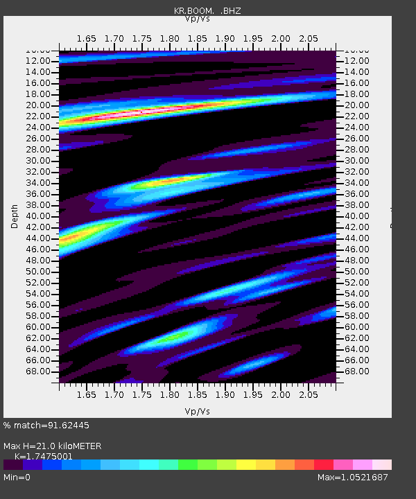
| Estimated Moho Depth: |
21.0 km |
| Estimated Crust Vp/Vs: |
1.75 |
| Assumed Crust Vp: |
6.306 km/s |
| Estimated Crust Vs: |
3.609 km/s |
| Estimated Crust Poisson's Ratio: |
0.26 |
|
| Radial Match: |
91.62445 % |
| Radial Bump: |
400 |
| Transverse Match: |
89.344986 % |
| Transverse Bump: |
400 |
| SOD ConfigId: |
463687 |
| Insert Time: |
2013-02-20 19:56:30.538 +0000 |
| GWidth: |
2.5 |
| Max Bumps: |
400 |
| Tol: |
0.001 |
|

Signal To Noise
| Channel | StoN | STA | LTA |
| KR:BOOM: :BHZ:20120708T11:41:42.925005Z | 24.672152 | 1.1044544E-6 | 4.4765226E-8 |
| KR:BOOM: :BHN:20120708T11:41:42.925005Z | 17.656996 | 3.6076494E-7 | 2.0431841E-8 |
| KR:BOOM: :BHE:20120708T11:41:42.925005Z | 8.58854 | 3.6149626E-7 | 4.2090534E-8 |
| Arrivals |
| Ps | 2.6 SECOND |
| PpPs | 8.7 SECOND |
| PsPs/PpSs | 11 SECOND |


