You are here: Home > Network List > KR - Kyrgyz Digital Network Stations List
> Station FRU1 Bishkek, Kyrgyzstan > Earthquake Result Viewer
FRU1 Bishkek, Kyrgyzstan - Earthquake Result Viewer
| Earthquake location: |
Kuril Islands |
| Earthquake latitude/longitude: |
45.5/151.3 |
| Earthquake time(UTC): |
2012/07/08 (190) 11:33:02 GMT |
| Earthquake Depth: |
20 km |
| Earthquake Magnitude: |
5.7 MB, 5.6 MS, 6.0 MW, 5.8 MW |
| Earthquake Catalog/Contributor: |
WHDF/NEIC |
|
| Network: |
KR Kyrgyz Digital Network |
| Station: |
FRU1 Bishkek, Kyrgyzstan |
| Lat/Lon: |
42.81 N/74.63 E |
| Elevation: |
929 m |
|
| Distance: |
53.1 deg |
| Az: |
296.409 deg |
| Baz: |
58.878 deg |
| Ray Param: |
0.06631811 |
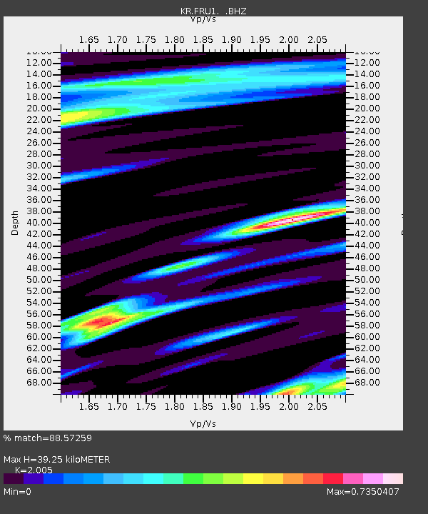
| Estimated Moho Depth: |
39.25 km |
| Estimated Crust Vp/Vs: |
2.01 |
| Assumed Crust Vp: |
6.306 km/s |
| Estimated Crust Vs: |
3.145 km/s |
| Estimated Crust Poisson's Ratio: |
0.33 |
|
| Radial Match: |
88.57259 % |
| Radial Bump: |
400 |
| Transverse Match: |
76.32368 % |
| Transverse Bump: |
400 |
| SOD ConfigId: |
463687 |
| Insert Time: |
2013-02-20 19:56:42.535 +0000 |
| GWidth: |
2.5 |
| Max Bumps: |
400 |
| Tol: |
0.001 |
|

Signal To Noise
| Channel | StoN | STA | LTA |
| KR:FRU1: :BHZ:20120708T11:41:47.825029Z | 14.458959 | 1.5068272E-6 | 1.04214095E-7 |
| KR:FRU1: :BHN:20120708T11:41:47.825029Z | 2.4472096 | 2.2903457E-7 | 9.3590096E-8 |
| KR:FRU1: :BHE:20120708T11:41:47.825029Z | 5.1752095 | 4.8446464E-7 | 9.361256E-8 |
| Arrivals |
| Ps | 6.6 SECOND |
| PpPs | 18 SECOND |
| PsPs/PpSs | 24 SECOND |


