You are here: Home > Network List > NE - New England Seismic Network Stations List
> Station EMMW Machias, ME, USA > Earthquake Result Viewer
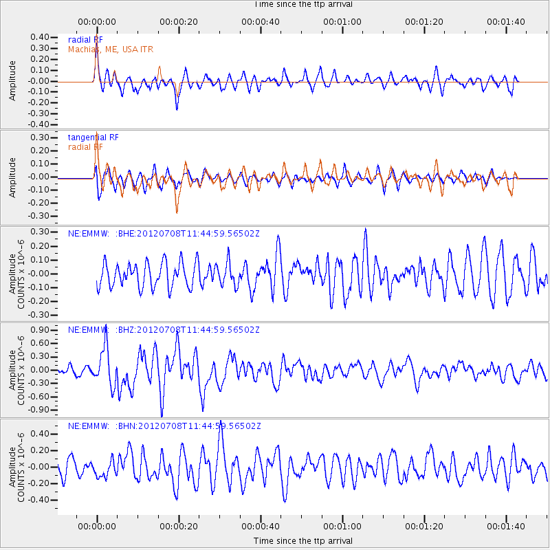
EMMW Machias, ME, USA - Earthquake Result Viewer
*The percent match for this event was below the threshold and hence no stack was calculated.
| Earthquake location: |
Kuril Islands |
| Earthquake latitude/longitude: |
45.5/151.3 |
| Earthquake time(UTC): |
2012/07/08 (190) 11:33:02 GMT |
| Earthquake Depth: |
20 km |
| Earthquake Magnitude: |
5.7 MB, 5.6 MS, 6.0 MW, 5.8 MW |
| Earthquake Catalog/Contributor: |
WHDF/NEIC |
|
| Network: |
NE New England Seismic Network |
| Station: |
EMMW Machias, ME, USA |
| Lat/Lon: |
44.71 N/67.46 W |
| Elevation: |
35 m |
|
| Distance: |
83.8 deg |
| Az: |
26.671 deg |
| Baz: |
333.721 deg |
| Ray Param: |
$rayparam |
*The percent match for this event was below the threshold and hence was not used in the summary stack. |
|
| Radial Match: |
72.08076 % |
| Radial Bump: |
400 |
| Transverse Match: |
57.642113 % |
| Transverse Bump: |
400 |
| SOD ConfigId: |
463687 |
| Insert Time: |
2013-02-20 20:03:20.941 +0000 |
| GWidth: |
2.5 |
| Max Bumps: |
400 |
| Tol: |
0.001 |
|
Signal To Noise
| Channel | StoN | STA | LTA |
| NE:EMMW: :BHZ:20120708T11:44:59.56502Z | 4.412783 | 4.3448227E-7 | 9.8459914E-8 |
| NE:EMMW: :BHN:20120708T11:44:59.56502Z | 0.685004 | 9.8821396E-8 | 1.4426396E-7 |
| NE:EMMW: :BHE:20120708T11:44:59.56502Z | 0.95243174 | 8.245953E-8 | 8.6577884E-8 |
| Arrivals |
| Ps | |
| PpPs | |
| PsPs/PpSs | |


