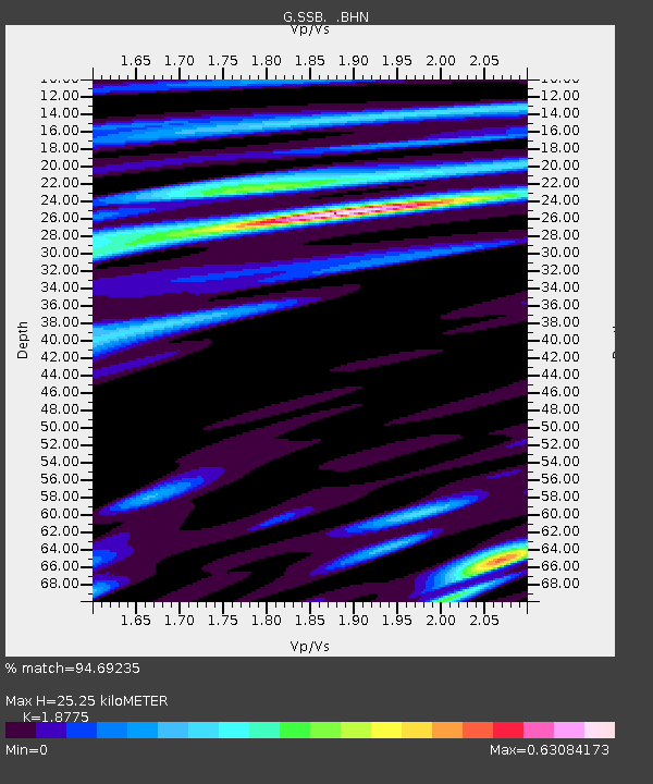
SSB Saint Sauveur Badole, France - Earthquake Result Viewer
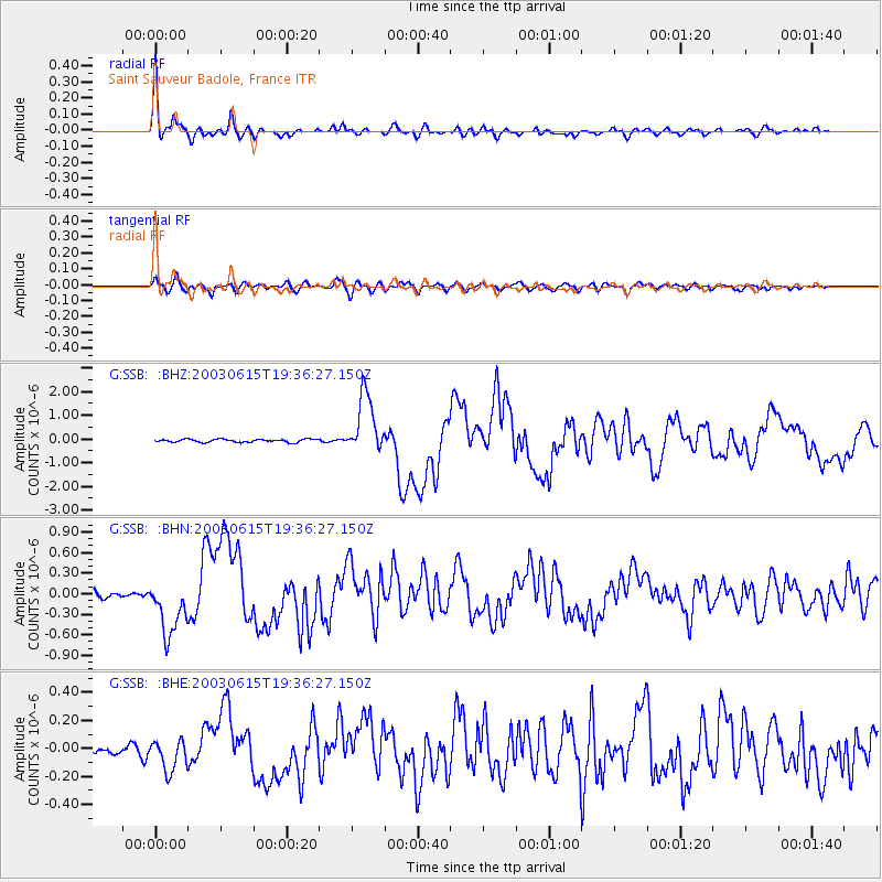
Earthquake location: Rat Islands, Aleutian Islands
Earthquake latitude/longitude: 51.6/176.9
Earthquake time(UTC): 2003/06/15 (166) 19:24:33 GMT
Earthquake Depth: 20 km
Earthquake Magnitude: 6.0 MB, 6.4 MS, 6.5 MW, 6.5 MW
Earthquake Catalog/Contributor: WHDF/NEIC
Network: G GEOSCOPE
Station: SSB Saint Sauveur Badole, France
Lat/Lon: 45.28 N/4.54 E
Elevation: 700 m
Distance: 83.3 deg
Az: 354.592 deg
Baz: 4.781 deg
Ray Param: 0.04625135
Estimated Moho Depth: 25.25 km
Estimated Crust Vp/Vs: 1.88
Assumed Crust Vp: 6.1 km/s
Estimated Crust Vs: 3.249 km/s
Estimated Crust Poisson's Ratio: 0.30
Radial Match: 94.69235 %
Radial Bump: 393
Transverse Match: 84.87956 %
Transverse Bump: 400
SOD ConfigId: 4714
Insert Time: 2010-02-27 00:15:10.121 +0000
GWidth: 2.5
Max Bumps: 400
Tol: 0.001

Signal To Noise

ChannelStoNSTALTA
G:SSB: :BHN:20030615T19:36:27.150Z9.3597874.114346E-74.3957687E-8
G:SSB: :BHE:20030615T19:36:27.150Z3.32449631.11256256E-73.34656E-8
G:SSB: :BHZ:20030615T19:36:27.150Z19.4563221.2515538E-66.4326336E-8
Arrivals
Ps3.7 SECOND
PpPs12 SECOND
PsPs/PpSs15 SECOND