You are here: Home > Network List > TA - USArray Transportable Network (new EarthScope stations) Stations List
> Station Q24A Divide, CO, USA > Earthquake Result Viewer
Q24A Divide, CO, USA - Earthquake Result Viewer
| Earthquake location: |
Kuril Islands |
| Earthquake latitude/longitude: |
45.5/151.3 |
| Earthquake time(UTC): |
2012/07/08 (190) 11:33:02 GMT |
| Earthquake Depth: |
20 km |
| Earthquake Magnitude: |
5.7 MB, 5.6 MS, 6.0 MW, 5.8 MW |
| Earthquake Catalog/Contributor: |
WHDF/NEIC |
|
| Network: |
TA USArray Transportable Network (new EarthScope stations) |
| Station: |
Q24A Divide, CO, USA |
| Lat/Lon: |
38.96 N/105.15 W |
| Elevation: |
2775 m |
|
| Distance: |
71.5 deg |
| Az: |
53.031 deg |
| Baz: |
313.879 deg |
| Ray Param: |
0.05423863 |
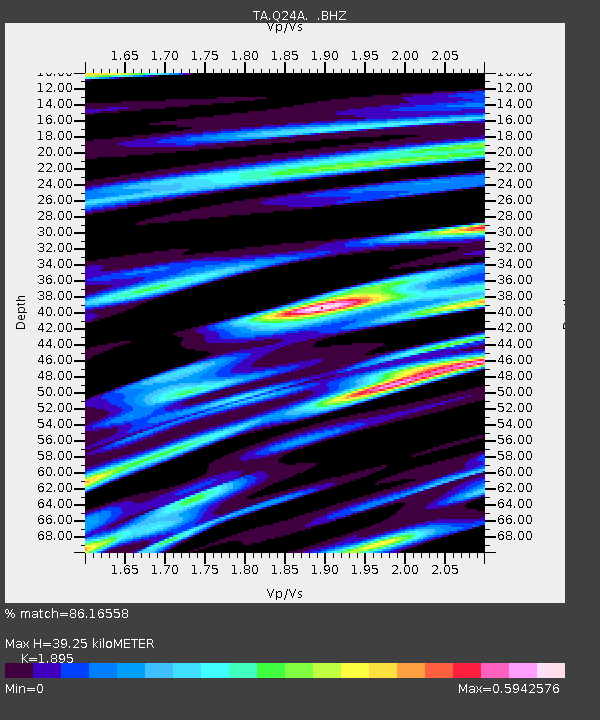
| Estimated Moho Depth: |
39.25 km |
| Estimated Crust Vp/Vs: |
1.89 |
| Assumed Crust Vp: |
6.159 km/s |
| Estimated Crust Vs: |
3.25 km/s |
| Estimated Crust Poisson's Ratio: |
0.31 |
|
| Radial Match: |
86.16558 % |
| Radial Bump: |
400 |
| Transverse Match: |
70.16153 % |
| Transverse Bump: |
400 |
| SOD ConfigId: |
463687 |
| Insert Time: |
2013-02-20 20:09:50.188 +0000 |
| GWidth: |
2.5 |
| Max Bumps: |
400 |
| Tol: |
0.001 |
|

Signal To Noise
| Channel | StoN | STA | LTA |
| TA:Q24A: :BHZ:20120708T11:43:51.224993Z | 3.9613526 | 1.791687E-7 | 4.522917E-8 |
| TA:Q24A: :BHN:20120708T11:43:51.224993Z | 2.5864043 | 1.14703845E-7 | 4.434877E-8 |
| TA:Q24A: :BHE:20120708T11:43:51.224993Z | 2.2649813 | 1.01642186E-7 | 4.4875506E-8 |
| Arrivals |
| Ps | 5.9 SECOND |
| PpPs | 18 SECOND |
| PsPs/PpSs | 24 SECOND |


