You are here: Home > Network List > TA - USArray Transportable Network (new EarthScope stations) Stations List
> Station TPFO Pinon Flats, CA, USA > Earthquake Result Viewer
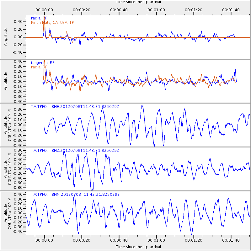
TPFO Pinon Flats, CA, USA - Earthquake Result Viewer
*The percent match for this event was below the threshold and hence no stack was calculated.
| Earthquake location: |
Kuril Islands |
| Earthquake latitude/longitude: |
45.5/151.3 |
| Earthquake time(UTC): |
2012/07/08 (190) 11:33:02 GMT |
| Earthquake Depth: |
20 km |
| Earthquake Magnitude: |
5.7 MB, 5.6 MS, 6.0 MW, 5.8 MW |
| Earthquake Catalog/Contributor: |
WHDF/NEIC |
|
| Network: |
TA USArray Transportable Network (new EarthScope stations) |
| Station: |
TPFO Pinon Flats, CA, USA |
| Lat/Lon: |
33.61 N/116.45 W |
| Elevation: |
1275 m |
|
| Distance: |
68.4 deg |
| Az: |
63.772 deg |
| Baz: |
310.888 deg |
| Ray Param: |
$rayparam |
*The percent match for this event was below the threshold and hence was not used in the summary stack. |
|
| Radial Match: |
68.802536 % |
| Radial Bump: |
400 |
| Transverse Match: |
63.71145 % |
| Transverse Bump: |
354 |
| SOD ConfigId: |
463687 |
| Insert Time: |
2013-02-20 20:13:10.352 +0000 |
| GWidth: |
2.5 |
| Max Bumps: |
400 |
| Tol: |
0.001 |
|
Signal To Noise
| Channel | StoN | STA | LTA |
| TA:TPFO: :BHZ:20120708T11:43:31.825029Z | 2.3591635 | 2.050691E-7 | 8.6924494E-8 |
| TA:TPFO: :BHN:20120708T11:43:31.825029Z | 0.8324819 | 1.2667395E-7 | 1.5216422E-7 |
| TA:TPFO: :BHE:20120708T11:43:31.825029Z | 2.0652578 | 2.3167252E-7 | 1.1217608E-7 |
| Arrivals |
| Ps | |
| PpPs | |
| PsPs/PpSs | |


