You are here: Home > Network List > TA - USArray Transportable Network (new EarthScope stations) Stations List
> Station F34A Alexandria, MN, USA > Earthquake Result Viewer
F34A Alexandria, MN, USA - Earthquake Result Viewer

| Earthquake location: |
Kuril Islands |
| Earthquake latitude/longitude: |
45.5/151.3 |
| Earthquake time(UTC): |
2012/07/08 (190) 11:33:02 GMT |
| Earthquake Depth: |
20 km |
| Earthquake Magnitude: |
5.7 MB, 5.6 MS, 6.0 MW, 5.8 MW |
| Earthquake Catalog/Contributor: |
WHDF/NEIC |
|
| Network: |
TA USArray Transportable Network (new EarthScope stations) |
| Station: |
F34A Alexandria, MN, USA |
| Lat/Lon: |
45.80 N/95.26 W |
| Elevation: |
419 m |
|
| Distance: |
71.8 deg |
| Az: |
42.498 deg |
| Baz: |
317.223 deg |
| Ray Param: |
0.054055415 |
| Estimated Moho Depth: |
32.25 km |
| Estimated Crust Vp/Vs: |
2.10 |
| Assumed Crust Vp: |
6.571 km/s |
| Estimated Crust Vs: |
3.133 km/s |
| Estimated Crust Poisson's Ratio: |
0.35 |
|
| Radial Match: |
89.150764 % |
| Radial Bump: |
351 |
| Transverse Match: |
75.495735 % |
| Transverse Bump: |
400 |
| SOD ConfigId: |
463687 |
| Insert Time: |
2013-02-20 20:15:55.696 +0000 |
| GWidth: |
2.5 |
| Max Bumps: |
400 |
| Tol: |
0.001 |
|
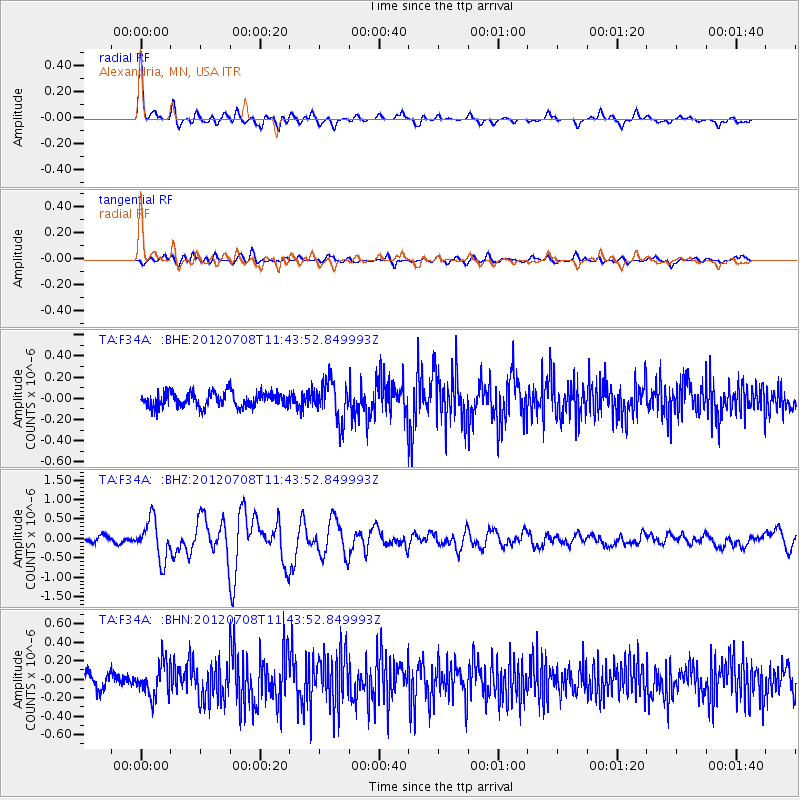
Signal To Noise
| Channel | StoN | STA | LTA |
| TA:F34A: :BHZ:20120708T11:43:52.849993Z | 6.764054 | 5.064049E-7 | 7.4867074E-8 |
| TA:F34A: :BHN:20120708T11:43:52.849993Z | 2.266338 | 1.753538E-7 | 7.737319E-8 |
| TA:F34A: :BHE:20120708T11:43:52.849993Z | 2.7105205 | 1.8746194E-7 | 6.916086E-8 |
| Arrivals |
| Ps | 5.6 SECOND |
| PpPs | 15 SECOND |
| PsPs/PpSs | 20 SECOND |


