You are here: Home > Network List > TA - USArray Transportable Network (new EarthScope stations) Stations List
> Station C38A Sawbill Landing (USFS), Superior Nat. Forest, MN, > Earthquake Result Viewer
C38A Sawbill Landing (USFS), Superior Nat. Forest, MN, - Earthquake Result Viewer
| Earthquake location: |
Kuril Islands |
| Earthquake latitude/longitude: |
45.5/151.3 |
| Earthquake time(UTC): |
2012/07/08 (190) 11:33:02 GMT |
| Earthquake Depth: |
20 km |
| Earthquake Magnitude: |
5.7 MB, 5.6 MS, 6.0 MW, 5.8 MW |
| Earthquake Catalog/Contributor: |
WHDF/NEIC |
|
| Network: |
TA USArray Transportable Network (new EarthScope stations) |
| Station: |
C38A Sawbill Landing (USFS), Superior Nat. Forest, MN, |
| Lat/Lon: |
47.72 N/91.27 W |
| Elevation: |
498 m |
|
| Distance: |
72.2 deg |
| Az: |
39.004 deg |
| Baz: |
319.039 deg |
| Ray Param: |
0.05378964 |
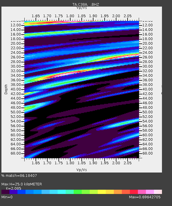
| Estimated Moho Depth: |
25.0 km |
| Estimated Crust Vp/Vs: |
2.09 |
| Assumed Crust Vp: |
6.467 km/s |
| Estimated Crust Vs: |
3.102 km/s |
| Estimated Crust Poisson's Ratio: |
0.35 |
|
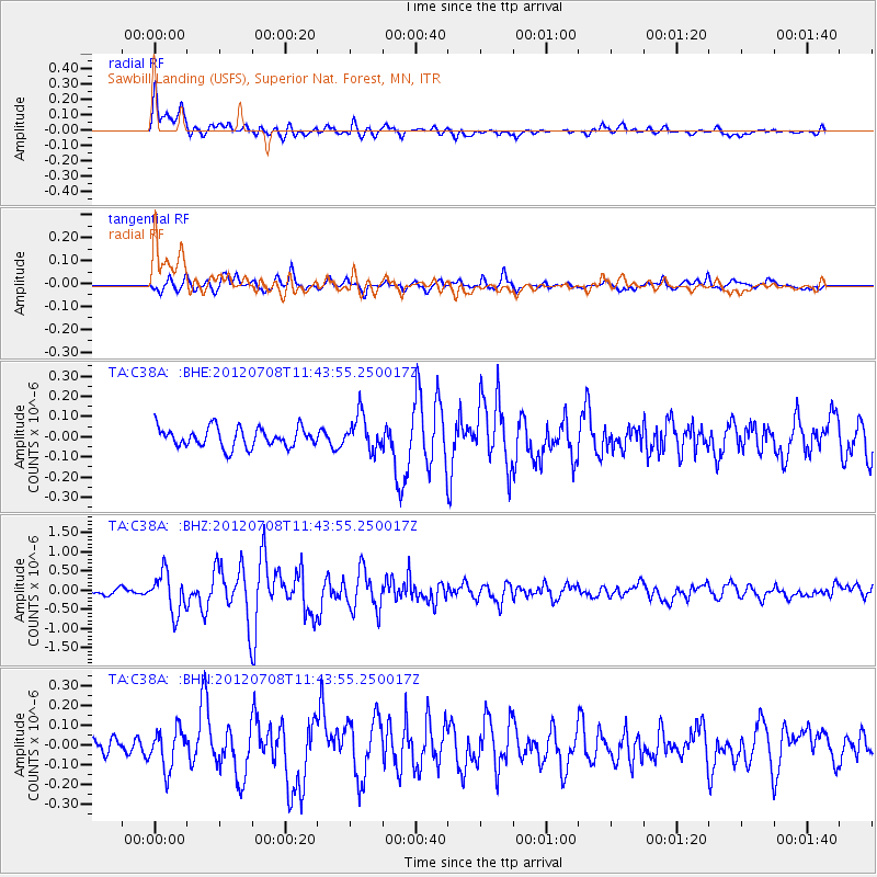
| Radial Match: |
86.18407 % |
| Radial Bump: |
400 |
| Transverse Match: |
78.48544 % |
| Transverse Bump: |
400 |
| SOD ConfigId: |
463687 |
| Insert Time: |
2013-02-20 20:17:32.113 +0000 |
| GWidth: |
2.5 |
| Max Bumps: |
400 |
| Tol: |
0.001 |
|
Signal To Noise
| Channel | StoN | STA | LTA |
| TA:C38A: :BHZ:20120708T11:43:55.250017Z | 7.5463934 | 5.177607E-7 | 6.861035E-8 |
| TA:C38A: :BHN:20120708T11:43:55.250017Z | 2.3148868 | 9.902759E-8 | 4.2778588E-8 |
| TA:C38A: :BHE:20120708T11:43:55.250017Z | 1.7782285 | 8.591901E-8 | 4.8317194E-8 |
| Arrivals |
| Ps | 4.3 SECOND |
| PpPs | 12 SECOND |
| PsPs/PpSs | 16 SECOND |


