You are here: Home > Network List > TA - USArray Transportable Network (new EarthScope stations) Stations List
> Station I36A Fitzsimmons Farm, Good Thunder, MN, USA > Earthquake Result Viewer
I36A Fitzsimmons Farm, Good Thunder, MN, USA - Earthquake Result Viewer

| Earthquake location: |
Kuril Islands |
| Earthquake latitude/longitude: |
45.5/151.3 |
| Earthquake time(UTC): |
2012/07/08 (190) 11:33:02 GMT |
| Earthquake Depth: |
20 km |
| Earthquake Magnitude: |
5.7 MB, 5.6 MS, 6.0 MW, 5.8 MW |
| Earthquake Catalog/Contributor: |
WHDF/NEIC |
|
| Network: |
TA USArray Transportable Network (new EarthScope stations) |
| Station: |
I36A Fitzsimmons Farm, Good Thunder, MN, USA |
| Lat/Lon: |
44.02 N/94.01 W |
| Elevation: |
307 m |
|
| Distance: |
73.7 deg |
| Az: |
43.063 deg |
| Baz: |
318.266 deg |
| Ray Param: |
0.05279305 |
| Estimated Moho Depth: |
13.0 km |
| Estimated Crust Vp/Vs: |
1.66 |
| Assumed Crust Vp: |
6.571 km/s |
| Estimated Crust Vs: |
3.946 km/s |
| Estimated Crust Poisson's Ratio: |
0.22 |
|
| Radial Match: |
81.122635 % |
| Radial Bump: |
400 |
| Transverse Match: |
66.21353 % |
| Transverse Bump: |
400 |
| SOD ConfigId: |
463687 |
| Insert Time: |
2013-02-20 20:17:44.478 +0000 |
| GWidth: |
2.5 |
| Max Bumps: |
400 |
| Tol: |
0.001 |
|
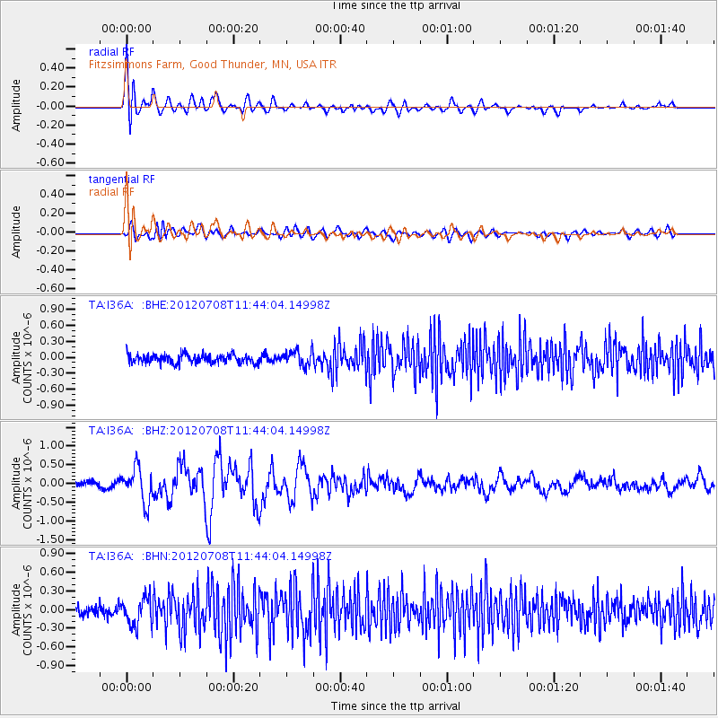
Signal To Noise
| Channel | StoN | STA | LTA |
| TA:I36A: :BHZ:20120708T11:44:04.14998Z | 6.0490065 | 4.6171218E-7 | 7.63286E-8 |
| TA:I36A: :BHN:20120708T11:44:04.14998Z | 2.8306692 | 2.2348964E-7 | 7.895294E-8 |
| TA:I36A: :BHE:20120708T11:44:04.14998Z | 1.7311819 | 1.4154799E-7 | 8.176379E-8 |
| Arrivals |
| Ps | 1.4 SECOND |
| PpPs | 5.1 SECOND |
| PsPs/PpSs | 6.4 SECOND |


