You are here: Home > Network List > TA - USArray Transportable Network (new EarthScope stations) Stations List
> Station H35A Sunnyside Ranch, Fairfax, MN, USA > Earthquake Result Viewer
H35A Sunnyside Ranch, Fairfax, MN, USA - Earthquake Result Viewer
| Earthquake location: |
Kuril Islands |
| Earthquake latitude/longitude: |
45.5/151.3 |
| Earthquake time(UTC): |
2012/07/08 (190) 11:33:02 GMT |
| Earthquake Depth: |
20 km |
| Earthquake Magnitude: |
5.7 MB, 5.6 MS, 6.0 MW, 5.8 MW |
| Earthquake Catalog/Contributor: |
WHDF/NEIC |
|
| Network: |
TA USArray Transportable Network (new EarthScope stations) |
| Station: |
H35A Sunnyside Ranch, Fairfax, MN, USA |
| Lat/Lon: |
44.70 N/94.83 W |
| Elevation: |
345 m |
|
| Distance: |
72.8 deg |
| Az: |
43.043 deg |
| Baz: |
317.691 deg |
| Ray Param: |
0.053384773 |
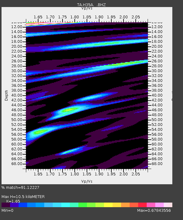
| Estimated Moho Depth: |
10.5 km |
| Estimated Crust Vp/Vs: |
1.65 |
| Assumed Crust Vp: |
6.571 km/s |
| Estimated Crust Vs: |
3.982 km/s |
| Estimated Crust Poisson's Ratio: |
0.21 |
|
| Radial Match: |
91.12227 % |
| Radial Bump: |
400 |
| Transverse Match: |
79.173256 % |
| Transverse Bump: |
400 |
| SOD ConfigId: |
463687 |
| Insert Time: |
2013-02-20 20:17:55.486 +0000 |
| GWidth: |
2.5 |
| Max Bumps: |
400 |
| Tol: |
0.001 |
|
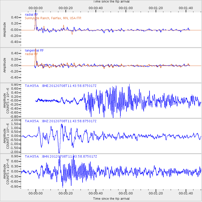
Signal To Noise
| Channel | StoN | STA | LTA |
| TA:H35A: :BHZ:20120708T11:43:58.875017Z | 11.082795 | 6.633539E-7 | 5.9854386E-8 |
| TA:H35A: :BHN:20120708T11:43:58.875017Z | 3.7146165 | 2.0685378E-7 | 5.5686446E-8 |
| TA:H35A: :BHE:20120708T11:43:58.875017Z | 3.6809812 | 1.8749566E-7 | 5.0936325E-8 |
| Arrivals |
| Ps | 1.1 SECOND |
| PpPs | 4.1 SECOND |
| PsPs/PpSs | 5.2 SECOND |


