You are here: Home > Network List > TA - USArray Transportable Network (new EarthScope stations) Stations List
> Station I38A Scanlan Farm, Eyota, MN, USA > Earthquake Result Viewer
I38A Scanlan Farm, Eyota, MN, USA - Earthquake Result Viewer
| Earthquake location: |
Kuril Islands |
| Earthquake latitude/longitude: |
45.5/151.3 |
| Earthquake time(UTC): |
2012/07/08 (190) 11:33:02 GMT |
| Earthquake Depth: |
20 km |
| Earthquake Magnitude: |
5.7 MB, 5.6 MS, 6.0 MW, 5.8 MW |
| Earthquake Catalog/Contributor: |
WHDF/NEIC |
|
| Network: |
TA USArray Transportable Network (new EarthScope stations) |
| Station: |
I38A Scanlan Farm, Eyota, MN, USA |
| Lat/Lon: |
44.04 N/92.33 W |
| Elevation: |
390 m |
|
| Distance: |
74.5 deg |
| Az: |
42.1 deg |
| Baz: |
319.168 deg |
| Ray Param: |
0.05226536 |
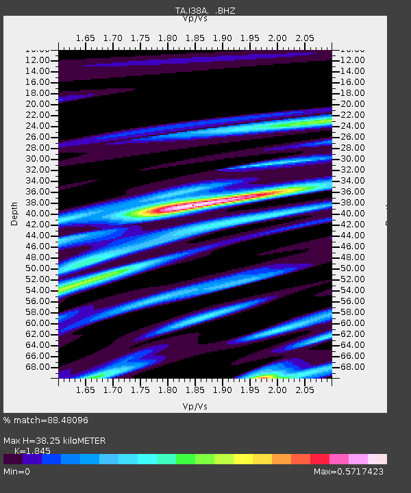
| Estimated Moho Depth: |
38.25 km |
| Estimated Crust Vp/Vs: |
1.85 |
| Assumed Crust Vp: |
6.571 km/s |
| Estimated Crust Vs: |
3.561 km/s |
| Estimated Crust Poisson's Ratio: |
0.29 |
|
| Radial Match: |
88.48096 % |
| Radial Bump: |
368 |
| Transverse Match: |
70.3794 % |
| Transverse Bump: |
400 |
| SOD ConfigId: |
463687 |
| Insert Time: |
2013-02-20 20:19:06.379 +0000 |
| GWidth: |
2.5 |
| Max Bumps: |
400 |
| Tol: |
0.001 |
|
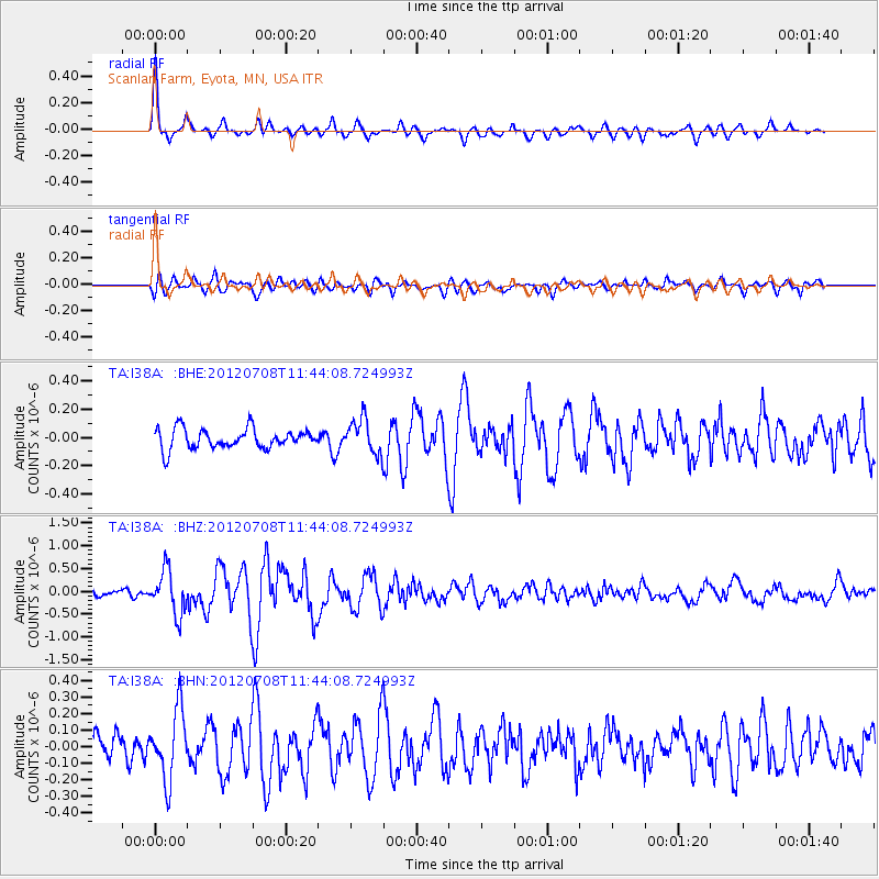
Signal To Noise
| Channel | StoN | STA | LTA |
| TA:I38A: :BHZ:20120708T11:44:08.724993Z | 6.982247 | 4.7427645E-7 | 6.792605E-8 |
| TA:I38A: :BHN:20120708T11:44:08.724993Z | 2.717892 | 2.0894788E-7 | 7.687866E-8 |
| TA:I38A: :BHE:20120708T11:44:08.724993Z | 1.7744513 | 1.2354977E-7 | 6.962703E-8 |
| Arrivals |
| Ps | 5.1 SECOND |
| PpPs | 16 SECOND |
| PsPs/PpSs | 21 SECOND |


