You are here: Home > Network List > CN - Canadian National Seismograph Network Stations List
> Station INK INUVIK, NT > Earthquake Result Viewer
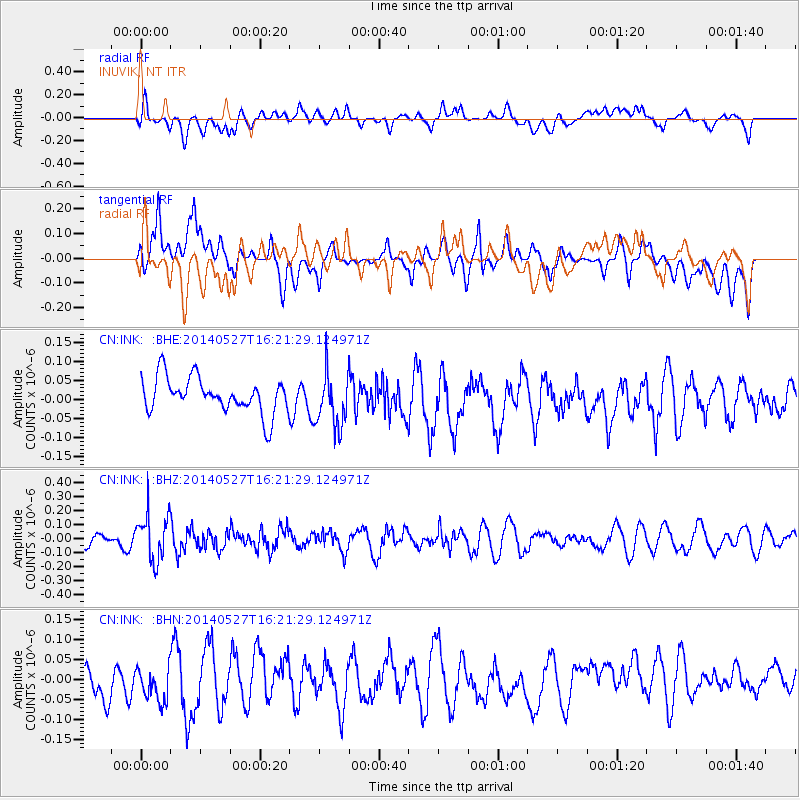
INK INUVIK, NT - Earthquake Result Viewer
*The percent match for this event was below the threshold and hence no stack was calculated.
| Earthquake location: |
Southeast Of Honshu, Japan |
| Earthquake latitude/longitude: |
32.5/140.7 |
| Earthquake time(UTC): |
2014/05/27 (147) 16:12:09 GMT |
| Earthquake Depth: |
74 km |
| Earthquake Magnitude: |
4.9 MW |
| Earthquake Catalog/Contributor: |
ISC/ISC |
|
| Network: |
CN Canadian National Seismograph Network |
| Station: |
INK INUVIK, NT |
| Lat/Lon: |
68.31 N/133.53 W |
| Elevation: |
44 m |
|
| Distance: |
58.7 deg |
| Az: |
25.717 deg |
| Baz: |
279.535 deg |
| Ray Param: |
$rayparam |
*The percent match for this event was below the threshold and hence was not used in the summary stack. |
|
| Radial Match: |
61.580086 % |
| Radial Bump: |
400 |
| Transverse Match: |
44.834305 % |
| Transverse Bump: |
400 |
| SOD ConfigId: |
3390531 |
| Insert Time: |
2019-04-12 01:33:15.543 +0000 |
| GWidth: |
2.5 |
| Max Bumps: |
400 |
| Tol: |
0.001 |
|
Signal To Noise
| Channel | StoN | STA | LTA |
| CN:INK: :BHZ:20140527T16:21:29.124971Z | 2.3902266 | 1.6619808E-7 | 6.9532355E-8 |
| CN:INK: :BHN:20140527T16:21:29.124971Z | 0.9431638 | 4.5896694E-8 | 4.8662486E-8 |
| CN:INK: :BHE:20140527T16:21:29.124971Z | 1.5616845 | 7.157511E-8 | 4.583199E-8 |
| Arrivals |
| Ps | |
| PpPs | |
| PsPs/PpSs | |


