You are here: Home > Network List > TA - USArray Transportable Network (new EarthScope stations) Stations List
> Station L37A Phoenix Point, Boone, IA, USA > Earthquake Result Viewer
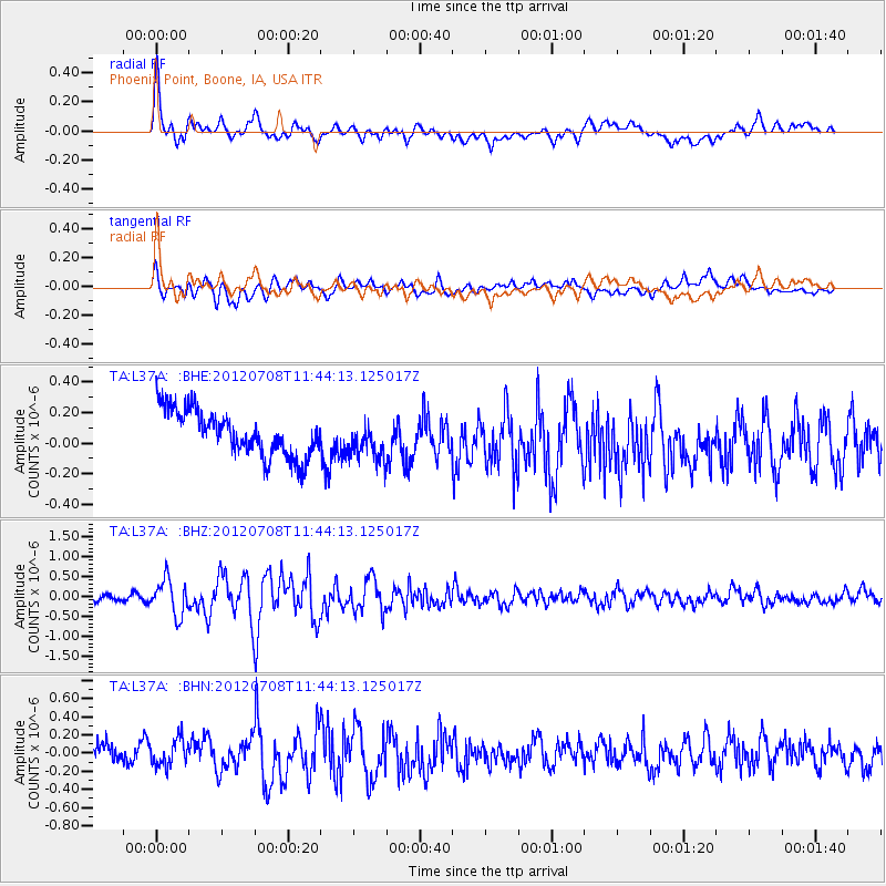
L37A Phoenix Point, Boone, IA, USA - Earthquake Result Viewer
*The percent match for this event was below the threshold and hence no stack was calculated.
| Earthquake location: |
Kuril Islands |
| Earthquake latitude/longitude: |
45.5/151.3 |
| Earthquake time(UTC): |
2012/07/08 (190) 11:33:02 GMT |
| Earthquake Depth: |
20 km |
| Earthquake Magnitude: |
5.7 MB, 5.6 MS, 6.0 MW, 5.8 MW |
| Earthquake Catalog/Contributor: |
WHDF/NEIC |
|
| Network: |
TA USArray Transportable Network (new EarthScope stations) |
| Station: |
L37A Phoenix Point, Boone, IA, USA |
| Lat/Lon: |
42.12 N/93.75 W |
| Elevation: |
312 m |
|
| Distance: |
75.3 deg |
| Az: |
44.217 deg |
| Baz: |
318.751 deg |
| Ray Param: |
$rayparam |
*The percent match for this event was below the threshold and hence was not used in the summary stack. |
|
| Radial Match: |
63.24531 % |
| Radial Bump: |
400 |
| Transverse Match: |
75.049484 % |
| Transverse Bump: |
400 |
| SOD ConfigId: |
463687 |
| Insert Time: |
2013-02-20 20:22:33.291 +0000 |
| GWidth: |
2.5 |
| Max Bumps: |
400 |
| Tol: |
0.001 |
|
Signal To Noise
| Channel | StoN | STA | LTA |
| TA:L37A: :BHZ:20120708T11:44:13.125017Z | 5.5025764 | 4.473312E-7 | 8.1294864E-8 |
| TA:L37A: :BHN:20120708T11:44:13.125017Z | 1.0215496 | 1.5731611E-7 | 1.5399753E-7 |
| TA:L37A: :BHE:20120708T11:44:13.125017Z | 0.8428184 | 1.2466613E-7 | 1.4791577E-7 |
| Arrivals |
| Ps | |
| PpPs | |
| PsPs/PpSs | |


