You are here: Home > Network List > TA - USArray Transportable Network (new EarthScope stations) Stations List
> Station P40A Paris, MO, USA > Earthquake Result Viewer
P40A Paris, MO, USA - Earthquake Result Viewer
| Earthquake location: |
Kuril Islands |
| Earthquake latitude/longitude: |
45.5/151.3 |
| Earthquake time(UTC): |
2012/07/08 (190) 11:33:02 GMT |
| Earthquake Depth: |
20 km |
| Earthquake Magnitude: |
5.7 MB, 5.6 MS, 6.0 MW, 5.8 MW |
| Earthquake Catalog/Contributor: |
WHDF/NEIC |
|
| Network: |
TA USArray Transportable Network (new EarthScope stations) |
| Station: |
P40A Paris, MO, USA |
| Lat/Lon: |
39.53 N/92.05 W |
| Elevation: |
225 m |
|
| Distance: |
78.1 deg |
| Az: |
44.94 deg |
| Baz: |
320.03 deg |
| Ray Param: |
0.049866427 |
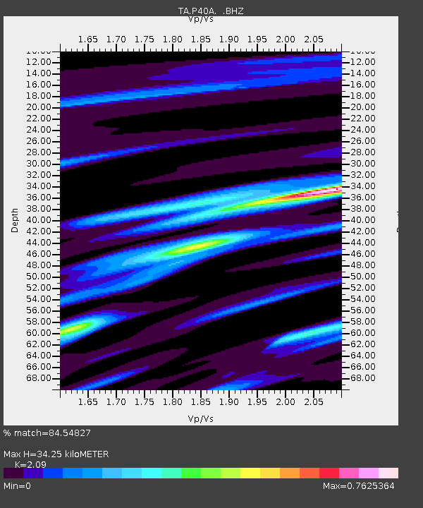
| Estimated Moho Depth: |
34.25 km |
| Estimated Crust Vp/Vs: |
2.09 |
| Assumed Crust Vp: |
6.498 km/s |
| Estimated Crust Vs: |
3.109 km/s |
| Estimated Crust Poisson's Ratio: |
0.35 |
|
| Radial Match: |
84.54827 % |
| Radial Bump: |
327 |
| Transverse Match: |
73.50735 % |
| Transverse Bump: |
400 |
| SOD ConfigId: |
463687 |
| Insert Time: |
2013-02-20 20:24:57.174 +0000 |
| GWidth: |
2.5 |
| Max Bumps: |
400 |
| Tol: |
0.001 |
|
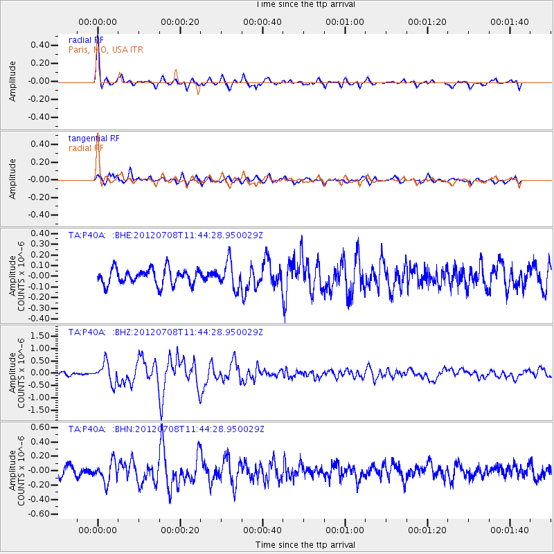
Signal To Noise
| Channel | StoN | STA | LTA |
| TA:P40A: :BHZ:20120708T11:44:28.950029Z | 5.390409 | 4.2302037E-7 | 7.847649E-8 |
| TA:P40A: :BHN:20120708T11:44:28.950029Z | 2.0094578 | 1.4563705E-7 | 7.247579E-8 |
| TA:P40A: :BHE:20120708T11:44:28.950029Z | 1.7232329 | 1.2664904E-7 | 7.349502E-8 |
| Arrivals |
| Ps | 5.9 SECOND |
| PpPs | 16 SECOND |
| PsPs/PpSs | 22 SECOND |


