You are here: Home > Network List > TA - USArray Transportable Network (new EarthScope stations) Stations List
> Station T40A Mansfield, MO, USA > Earthquake Result Viewer
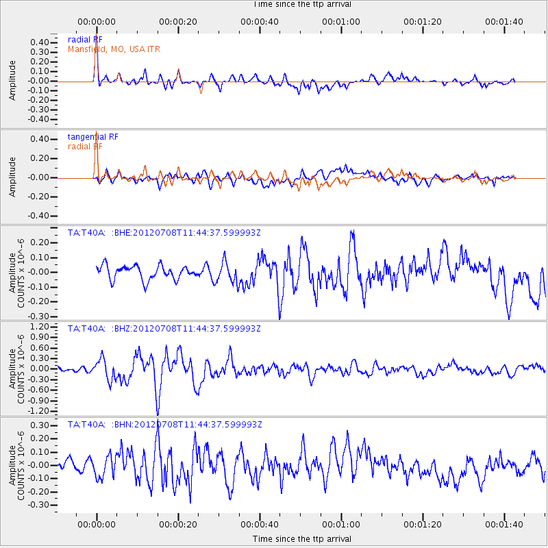
T40A Mansfield, MO, USA - Earthquake Result Viewer
*The percent match for this event was below the threshold and hence no stack was calculated.
| Earthquake location: |
Kuril Islands |
| Earthquake latitude/longitude: |
45.5/151.3 |
| Earthquake time(UTC): |
2012/07/08 (190) 11:33:02 GMT |
| Earthquake Depth: |
20 km |
| Earthquake Magnitude: |
5.7 MB, 5.6 MS, 6.0 MW, 5.8 MW |
| Earthquake Catalog/Contributor: |
WHDF/NEIC |
|
| Network: |
TA USArray Transportable Network (new EarthScope stations) |
| Station: |
T40A Mansfield, MO, USA |
| Lat/Lon: |
37.15 N/92.52 W |
| Elevation: |
399 m |
|
| Distance: |
79.7 deg |
| Az: |
46.784 deg |
| Baz: |
320.094 deg |
| Ray Param: |
$rayparam |
*The percent match for this event was below the threshold and hence was not used in the summary stack. |
|
| Radial Match: |
76.00784 % |
| Radial Bump: |
400 |
| Transverse Match: |
52.521183 % |
| Transverse Bump: |
400 |
| SOD ConfigId: |
463687 |
| Insert Time: |
2013-02-20 20:26:09.347 +0000 |
| GWidth: |
2.5 |
| Max Bumps: |
400 |
| Tol: |
0.001 |
|
Signal To Noise
| Channel | StoN | STA | LTA |
| TA:T40A: :BHZ:20120708T11:44:37.599993Z | 4.301697 | 2.9916376E-7 | 6.954553E-8 |
| TA:T40A: :BHN:20120708T11:44:37.599993Z | 1.5337158 | 7.856917E-8 | 5.1227985E-8 |
| TA:T40A: :BHE:20120708T11:44:37.599993Z | 1.5396425 | 7.123795E-8 | 4.6269154E-8 |
| Arrivals |
| Ps | |
| PpPs | |
| PsPs/PpSs | |


