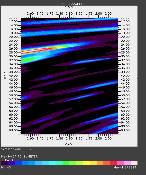
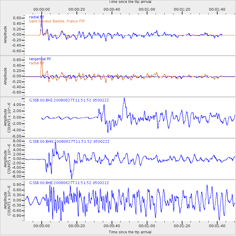
SSB Saint Sauveur Badole, France - Earthquake Result Viewer

Earthquake location: Andaman Islands, India Region
Earthquake latitude/longitude: 11.0/91.8
Earthquake time(UTC): 2008/06/27 (179) 11:40:13 GMT
Earthquake Depth: 17 km
Earthquake Magnitude: 6.4 MB, 6.7 MS, 6.6 MW, 6.6 MW
Earthquake Catalog/Contributor: WHDF/NEIC
Network: G GEOSCOPE
Station: SSB Saint Sauveur Badole, France
Lat/Lon: 45.28 N/4.54 E
Elevation: 700 m
Distance: 80.4 deg
Az: 314.331 deg
Baz: 84.124 deg
Ray Param: 0.048306376
Estimated Moho Depth: 27.75 km
Estimated Crust Vp/Vs: 1.60
Assumed Crust Vp: 6.1 km/s
Estimated Crust Vs: 3.812 km/s
Estimated Crust Poisson's Ratio: 0.18
Radial Match: 94.03052 %
Radial Bump: 400
Transverse Match: 80.46922 %
Transverse Bump: 400
SOD ConfigId: 2504
Insert Time: 2010-02-27 00:15:49.254 +0000
GWidth: 2.5
Max Bumps: 400
Tol: 0.001

Signal To Noise

ChannelStoNSTALTA
G:SSB:00:BHN:20080627T11:51:52.950022Z12.5169272.1080475E-61.6841574E-7
G:SSB:00:BHE:20080627T11:51:52.950022Z3.03167272.9550102E-79.7471286E-8
G:SSB:00:BHZ:20080627T11:51:52.950022Z4.7868561.0650414E-62.2249289E-7
Arrivals
Ps2.8 SECOND
PpPs12 SECOND
PsPs/PpSs14 SECOND