You are here: Home > Network List > TA - USArray Transportable Network (new EarthScope stations) Stations List
> Station 342A Flagon Creek Properties, Pineville, LA, USA > Earthquake Result Viewer
342A Flagon Creek Properties, Pineville, LA, USA - Earthquake Result Viewer
| Earthquake location: |
Kuril Islands |
| Earthquake latitude/longitude: |
45.5/151.3 |
| Earthquake time(UTC): |
2012/07/08 (190) 11:33:02 GMT |
| Earthquake Depth: |
20 km |
| Earthquake Magnitude: |
5.7 MB, 5.6 MS, 6.0 MW, 5.8 MW |
| Earthquake Catalog/Contributor: |
WHDF/NEIC |
|
| Network: |
TA USArray Transportable Network (new EarthScope stations) |
| Station: |
342A Flagon Creek Properties, Pineville, LA, USA |
| Lat/Lon: |
31.37 N/92.32 W |
| Elevation: |
37 m |
|
| Distance: |
84.2 deg |
| Az: |
50.367 deg |
| Baz: |
320.707 deg |
| Ray Param: |
0.045628335 |
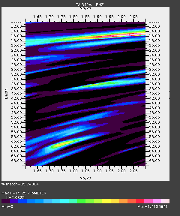
| Estimated Moho Depth: |
15.25 km |
| Estimated Crust Vp/Vs: |
2.03 |
| Assumed Crust Vp: |
6.065 km/s |
| Estimated Crust Vs: |
2.984 km/s |
| Estimated Crust Poisson's Ratio: |
0.34 |
|
| Radial Match: |
85.74004 % |
| Radial Bump: |
400 |
| Transverse Match: |
74.22865 % |
| Transverse Bump: |
400 |
| SOD ConfigId: |
463687 |
| Insert Time: |
2013-02-20 20:30:11.240 +0000 |
| GWidth: |
2.5 |
| Max Bumps: |
400 |
| Tol: |
0.001 |
|

Signal To Noise
| Channel | StoN | STA | LTA |
| TA:342A: :BHZ:20120708T11:45:01.39998Z | 5.1285987 | 4.6060248E-7 | 8.981059E-8 |
| TA:342A: :BHN:20120708T11:45:01.39998Z | 1.3626752 | 1.6379056E-7 | 1.201978E-7 |
| TA:342A: :BHE:20120708T11:45:01.39998Z | 0.89243996 | 9.802777E-8 | 1.09842425E-7 |
| Arrivals |
| Ps | 2.6 SECOND |
| PpPs | 7.5 SECOND |
| PsPs/PpSs | 10 SECOND |


