You are here: Home > Network List > TA - USArray Transportable Network (new EarthScope stations) Stations List
> Station Y46A Houston, MS, USA > Earthquake Result Viewer
Y46A Houston, MS, USA - Earthquake Result Viewer
| Earthquake location: |
Kuril Islands |
| Earthquake latitude/longitude: |
45.5/151.3 |
| Earthquake time(UTC): |
2012/07/08 (190) 11:33:02 GMT |
| Earthquake Depth: |
20 km |
| Earthquake Magnitude: |
5.7 MB, 5.6 MS, 6.0 MW, 5.8 MW |
| Earthquake Catalog/Contributor: |
WHDF/NEIC |
|
| Network: |
TA USArray Transportable Network (new EarthScope stations) |
| Station: |
Y46A Houston, MS, USA |
| Lat/Lon: |
33.88 N/88.86 W |
| Elevation: |
109 m |
|
| Distance: |
84.1 deg |
| Az: |
46.501 deg |
| Baz: |
322.173 deg |
| Ray Param: |
0.04571831 |
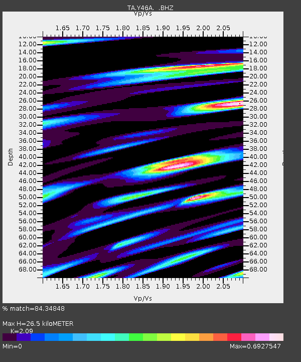
| Estimated Moho Depth: |
26.5 km |
| Estimated Crust Vp/Vs: |
2.09 |
| Assumed Crust Vp: |
6.201 km/s |
| Estimated Crust Vs: |
2.967 km/s |
| Estimated Crust Poisson's Ratio: |
0.35 |
|
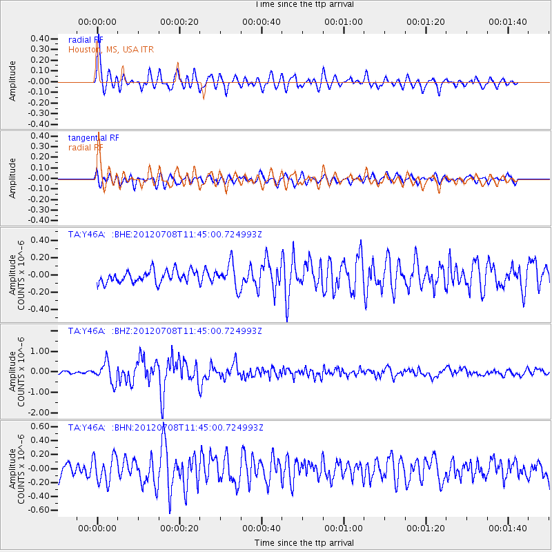
| Radial Match: |
84.34848 % |
| Radial Bump: |
400 |
| Transverse Match: |
65.74209 % |
| Transverse Bump: |
400 |
| SOD ConfigId: |
463687 |
| Insert Time: |
2013-02-20 20:34:18.165 +0000 |
| GWidth: |
2.5 |
| Max Bumps: |
400 |
| Tol: |
0.001 |
|
Signal To Noise
| Channel | StoN | STA | LTA |
| TA:Y46A: :BHZ:20120708T11:45:00.724993Z | 8.986898 | 5.060632E-7 | 5.631122E-8 |
| TA:Y46A: :BHN:20120708T11:45:00.724993Z | 2.507211 | 1.9128984E-7 | 7.629587E-8 |
| TA:Y46A: :BHE:20120708T11:45:00.724993Z | 2.1359084 | 1.4697584E-7 | 6.8811865E-8 |
| Arrivals |
| Ps | 4.8 SECOND |
| PpPs | 13 SECOND |
| PsPs/PpSs | 18 SECOND |


