You are here: Home > Network List > TA - USArray Transportable Network (new EarthScope stations) Stations List
> Station W44A Shelby Farms Park, Memphis, TN, USA > Earthquake Result Viewer
W44A Shelby Farms Park, Memphis, TN, USA - Earthquake Result Viewer

| Earthquake location: |
Kuril Islands |
| Earthquake latitude/longitude: |
45.5/151.3 |
| Earthquake time(UTC): |
2012/07/08 (190) 11:33:02 GMT |
| Earthquake Depth: |
20 km |
| Earthquake Magnitude: |
5.7 MB, 5.6 MS, 6.0 MW, 5.8 MW |
| Earthquake Catalog/Contributor: |
WHDF/NEIC |
|
| Network: |
TA USArray Transportable Network (new EarthScope stations) |
| Station: |
W44A Shelby Farms Park, Memphis, TN, USA |
| Lat/Lon: |
35.14 N/89.82 W |
| Elevation: |
101 m |
|
| Distance: |
82.6 deg |
| Az: |
46.349 deg |
| Baz: |
321.615 deg |
| Ray Param: |
0.046755943 |
| Estimated Moho Depth: |
12.75 km |
| Estimated Crust Vp/Vs: |
1.76 |
| Assumed Crust Vp: |
6.38 km/s |
| Estimated Crust Vs: |
3.615 km/s |
| Estimated Crust Poisson's Ratio: |
0.26 |
|
| Radial Match: |
90.109665 % |
| Radial Bump: |
318 |
| Transverse Match: |
78.098976 % |
| Transverse Bump: |
384 |
| SOD ConfigId: |
463687 |
| Insert Time: |
2013-02-20 20:36:29.851 +0000 |
| GWidth: |
2.5 |
| Max Bumps: |
400 |
| Tol: |
0.001 |
|
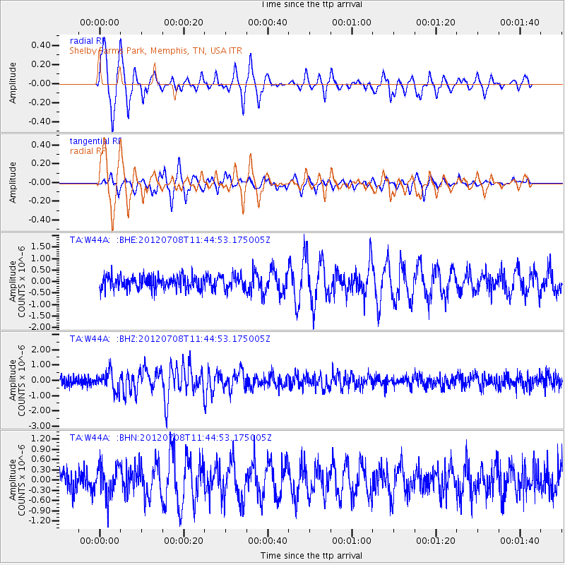
Signal To Noise
| Channel | StoN | STA | LTA |
| TA:W44A: :BHZ:20120708T11:44:53.175005Z | 2.295995 | 6.158433E-7 | 2.6822502E-7 |
| TA:W44A: :BHN:20120708T11:44:53.175005Z | 1.1993623 | 4.3828064E-7 | 3.6542806E-7 |
| TA:W44A: :BHE:20120708T11:44:53.175005Z | 1.0685347 | 2.9243176E-7 | 2.7367548E-7 |
| Arrivals |
| Ps | 1.6 SECOND |
| PpPs | 5.4 SECOND |
| PsPs/PpSs | 7.0 SECOND |


