You are here: Home > Network List > TA - USArray Transportable Network (new EarthScope stations) Stations List
> Station S43A Fulton Ridge, Patton, MO, USA > Earthquake Result Viewer
S43A Fulton Ridge, Patton, MO, USA - Earthquake Result Viewer
| Earthquake location: |
Kuril Islands |
| Earthquake latitude/longitude: |
45.5/151.3 |
| Earthquake time(UTC): |
2012/07/08 (190) 11:33:02 GMT |
| Earthquake Depth: |
20 km |
| Earthquake Magnitude: |
5.7 MB, 5.6 MS, 6.0 MW, 5.8 MW |
| Earthquake Catalog/Contributor: |
WHDF/NEIC |
|
| Network: |
TA USArray Transportable Network (new EarthScope stations) |
| Station: |
S43A Fulton Ridge, Patton, MO, USA |
| Lat/Lon: |
37.57 N/90.08 W |
| Elevation: |
263 m |
|
| Distance: |
80.6 deg |
| Az: |
44.985 deg |
| Baz: |
321.262 deg |
| Ray Param: |
0.048166376 |
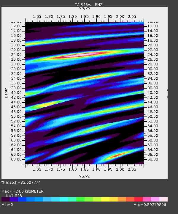
| Estimated Moho Depth: |
24.0 km |
| Estimated Crust Vp/Vs: |
1.83 |
| Assumed Crust Vp: |
6.53 km/s |
| Estimated Crust Vs: |
3.578 km/s |
| Estimated Crust Poisson's Ratio: |
0.29 |
|
| Radial Match: |
85.007774 % |
| Radial Bump: |
400 |
| Transverse Match: |
69.743004 % |
| Transverse Bump: |
400 |
| SOD ConfigId: |
463687 |
| Insert Time: |
2013-02-20 20:38:38.801 +0000 |
| GWidth: |
2.5 |
| Max Bumps: |
400 |
| Tol: |
0.001 |
|
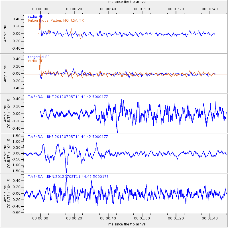
Signal To Noise
| Channel | StoN | STA | LTA |
| TA:S43A: :BHZ:20120708T11:44:42.500017Z | 6.340318 | 4.2267806E-7 | 6.6665116E-8 |
| TA:S43A: :BHN:20120708T11:44:42.500017Z | 1.9523007 | 1.1912172E-7 | 6.1016074E-8 |
| TA:S43A: :BHE:20120708T11:44:42.500017Z | 1.8864851 | 1.1922684E-7 | 6.320052E-8 |
| Arrivals |
| Ps | 3.1 SECOND |
| PpPs | 10 SECOND |
| PsPs/PpSs | 13 SECOND |


