You are here: Home > Network List > TA - USArray Transportable Network (new EarthScope stations) Stations List
> Station K41A Shullsburg, WI, USA > Earthquake Result Viewer
K41A Shullsburg, WI, USA - Earthquake Result Viewer
| Earthquake location: |
Kuril Islands |
| Earthquake latitude/longitude: |
45.5/151.3 |
| Earthquake time(UTC): |
2012/07/08 (190) 11:33:02 GMT |
| Earthquake Depth: |
20 km |
| Earthquake Magnitude: |
5.7 MB, 5.6 MS, 6.0 MW, 5.8 MW |
| Earthquake Catalog/Contributor: |
WHDF/NEIC |
|
| Network: |
TA USArray Transportable Network (new EarthScope stations) |
| Station: |
K41A Shullsburg, WI, USA |
| Lat/Lon: |
42.61 N/90.30 W |
| Elevation: |
298 m |
|
| Distance: |
76.6 deg |
| Az: |
41.887 deg |
| Baz: |
320.501 deg |
| Ray Param: |
0.050894182 |
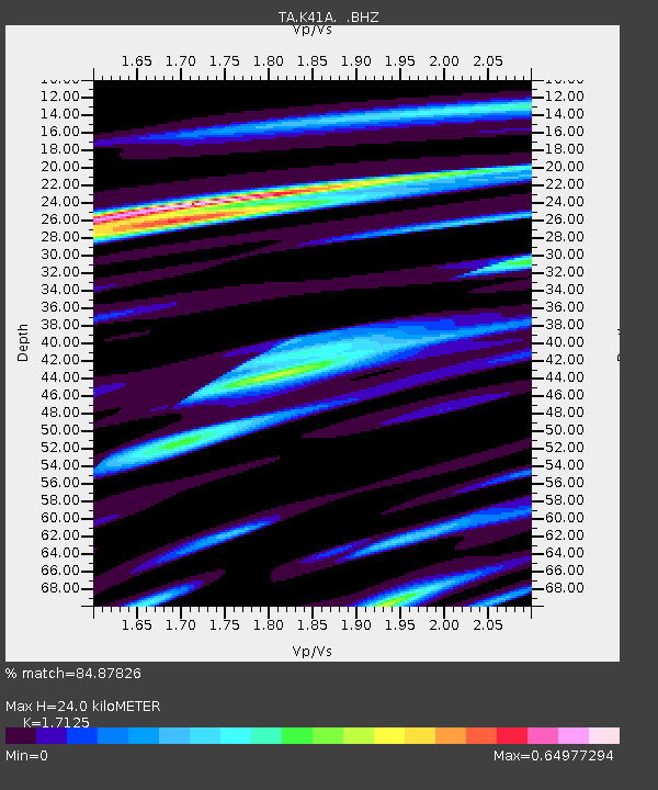
| Estimated Moho Depth: |
24.0 km |
| Estimated Crust Vp/Vs: |
1.71 |
| Assumed Crust Vp: |
6.53 km/s |
| Estimated Crust Vs: |
3.813 km/s |
| Estimated Crust Poisson's Ratio: |
0.24 |
|
| Radial Match: |
84.87826 % |
| Radial Bump: |
400 |
| Transverse Match: |
74.19229 % |
| Transverse Bump: |
400 |
| SOD ConfigId: |
463687 |
| Insert Time: |
2013-02-20 20:40:52.936 +0000 |
| GWidth: |
2.5 |
| Max Bumps: |
400 |
| Tol: |
0.001 |
|

Signal To Noise
| Channel | StoN | STA | LTA |
| TA:K41A: :BHZ:20120708T11:44:20.450029Z | 3.7740886 | 3.4613691E-7 | 9.1714035E-8 |
| TA:K41A: :BHN:20120708T11:44:20.450029Z | 2.4780877 | 1.490143E-7 | 6.013278E-8 |
| TA:K41A: :BHE:20120708T11:44:20.450029Z | 2.560574 | 1.7664617E-7 | 6.8986935E-8 |
| Arrivals |
| Ps | 2.7 SECOND |
| PpPs | 9.6 SECOND |
| PsPs/PpSs | 12 SECOND |


