You are here: Home > Network List > TA - USArray Transportable Network (new EarthScope stations) Stations List
> Station T44A Benton, MO, USA > Earthquake Result Viewer
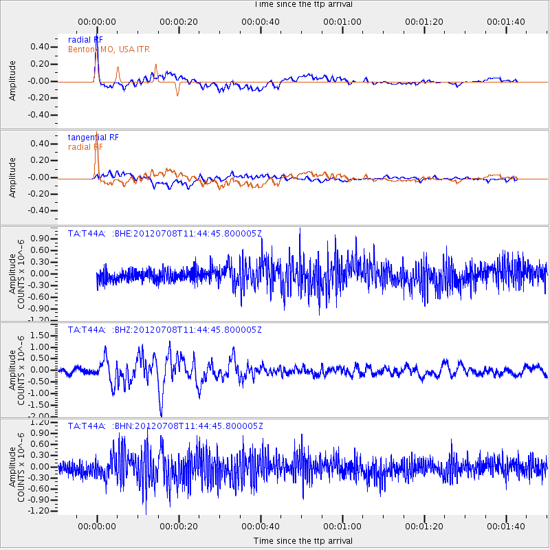
T44A Benton, MO, USA - Earthquake Result Viewer
*The percent match for this event was below the threshold and hence no stack was calculated.
| Earthquake location: |
Kuril Islands |
| Earthquake latitude/longitude: |
45.5/151.3 |
| Earthquake time(UTC): |
2012/07/08 (190) 11:33:02 GMT |
| Earthquake Depth: |
20 km |
| Earthquake Magnitude: |
5.7 MB, 5.6 MS, 6.0 MW, 5.8 MW |
| Earthquake Catalog/Contributor: |
WHDF/NEIC |
|
| Network: |
TA USArray Transportable Network (new EarthScope stations) |
| Station: |
T44A Benton, MO, USA |
| Lat/Lon: |
37.09 N/89.59 W |
| Elevation: |
133 m |
|
| Distance: |
81.2 deg |
| Az: |
44.984 deg |
| Baz: |
321.556 deg |
| Ray Param: |
$rayparam |
*The percent match for this event was below the threshold and hence was not used in the summary stack. |
|
| Radial Match: |
76.32766 % |
| Radial Bump: |
400 |
| Transverse Match: |
66.739746 % |
| Transverse Bump: |
400 |
| SOD ConfigId: |
463687 |
| Insert Time: |
2013-02-20 20:41:40.791 +0000 |
| GWidth: |
2.5 |
| Max Bumps: |
400 |
| Tol: |
0.001 |
|
Signal To Noise
| Channel | StoN | STA | LTA |
| TA:T44A: :BHZ:20120708T11:44:45.800005Z | 6.729006 | 5.129014E-7 | 7.622247E-8 |
| TA:T44A: :BHN:20120708T11:44:45.800005Z | 1.8956635 | 2.6684066E-7 | 1.4076372E-7 |
| TA:T44A: :BHE:20120708T11:44:45.800005Z | 1.8106031 | 2.4313252E-7 | 1.342826E-7 |
| Arrivals |
| Ps | |
| PpPs | |
| PsPs/PpSs | |


