You are here: Home > Network List > TA - USArray Transportable Network (new EarthScope stations) Stations List
> Station A36M Sachs Harbour, NT, CAN > Earthquake Result Viewer
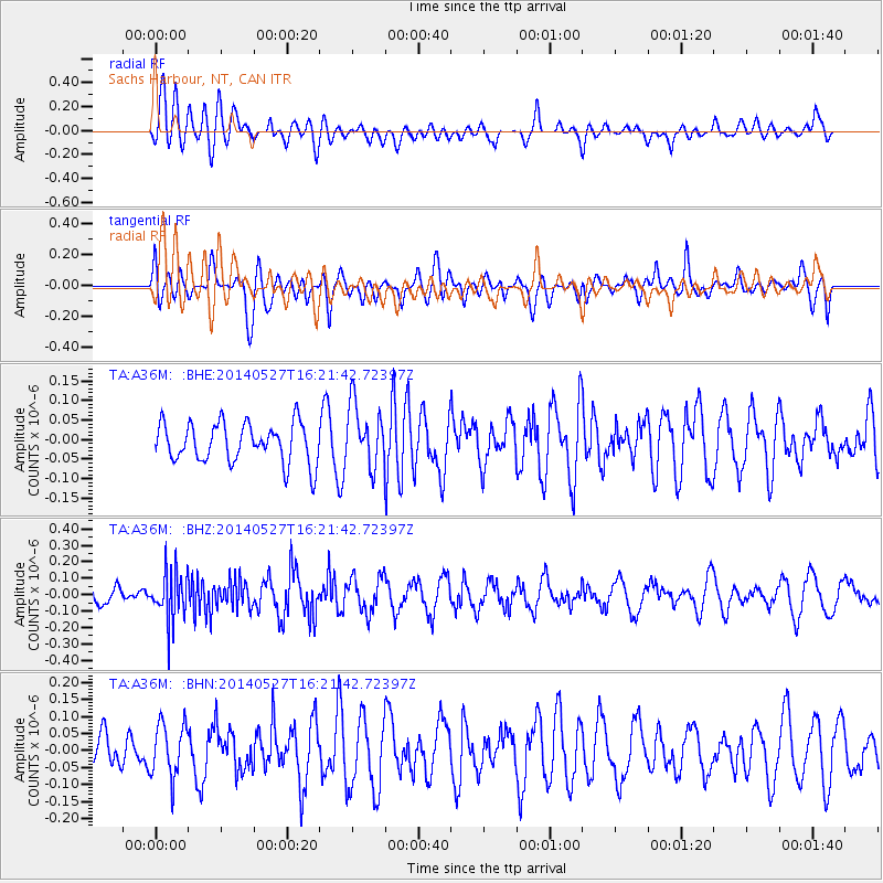
A36M Sachs Harbour, NT, CAN - Earthquake Result Viewer
*The percent match for this event was below the threshold and hence no stack was calculated.
| Earthquake location: |
Southeast Of Honshu, Japan |
| Earthquake latitude/longitude: |
32.5/140.7 |
| Earthquake time(UTC): |
2014/05/27 (147) 16:12:09 GMT |
| Earthquake Depth: |
74 km |
| Earthquake Magnitude: |
4.9 MW |
| Earthquake Catalog/Contributor: |
ISC/ISC |
|
| Network: |
TA USArray Transportable Network (new EarthScope stations) |
| Station: |
A36M Sachs Harbour, NT, CAN |
| Lat/Lon: |
71.99 N/125.25 W |
| Elevation: |
32 m |
|
| Distance: |
60.7 deg |
| Az: |
20.847 deg |
| Baz: |
284.863 deg |
| Ray Param: |
$rayparam |
*The percent match for this event was below the threshold and hence was not used in the summary stack. |
|
| Radial Match: |
66.51256 % |
| Radial Bump: |
400 |
| Transverse Match: |
51.070076 % |
| Transverse Bump: |
400 |
| SOD ConfigId: |
3390531 |
| Insert Time: |
2019-04-12 01:36:26.035 +0000 |
| GWidth: |
2.5 |
| Max Bumps: |
400 |
| Tol: |
0.001 |
|
Signal To Noise
| Channel | StoN | STA | LTA |
| TA:A36M: :BHZ:20140527T16:21:42.72397Z | 3.07376 | 1.4983172E-7 | 4.8745417E-8 |
| TA:A36M: :BHN:20140527T16:21:42.72397Z | 1.1036305 | 7.840768E-8 | 7.104523E-8 |
| TA:A36M: :BHE:20140527T16:21:42.72397Z | 1.5802606 | 7.9703725E-8 | 5.0437073E-8 |
| Arrivals |
| Ps | |
| PpPs | |
| PsPs/PpSs | |


