You are here: Home > Network List > TA - USArray Transportable Network (new EarthScope stations) Stations List
> Station F41A Wisconsin Rapids, WI, USA > Earthquake Result Viewer
F41A Wisconsin Rapids, WI, USA - Earthquake Result Viewer

| Earthquake location: |
Kuril Islands |
| Earthquake latitude/longitude: |
45.5/151.3 |
| Earthquake time(UTC): |
2012/07/08 (190) 11:33:02 GMT |
| Earthquake Depth: |
20 km |
| Earthquake Magnitude: |
5.7 MB, 5.6 MS, 6.0 MW, 5.8 MW |
| Earthquake Catalog/Contributor: |
WHDF/NEIC |
|
| Network: |
TA USArray Transportable Network (new EarthScope stations) |
| Station: |
F41A Wisconsin Rapids, WI, USA |
| Lat/Lon: |
45.74 N/89.10 W |
| Elevation: |
509 m |
|
| Distance: |
74.7 deg |
| Az: |
39.146 deg |
| Baz: |
320.654 deg |
| Ray Param: |
0.052145727 |
| Estimated Moho Depth: |
33.5 km |
| Estimated Crust Vp/Vs: |
1.97 |
| Assumed Crust Vp: |
6.41 km/s |
| Estimated Crust Vs: |
3.258 km/s |
| Estimated Crust Poisson's Ratio: |
0.33 |
|
| Radial Match: |
89.58678 % |
| Radial Bump: |
314 |
| Transverse Match: |
63.09789 % |
| Transverse Bump: |
400 |
| SOD ConfigId: |
466652 |
| Insert Time: |
2013-02-21 01:14:16.883 +0000 |
| GWidth: |
2.5 |
| Max Bumps: |
400 |
| Tol: |
0.001 |
|
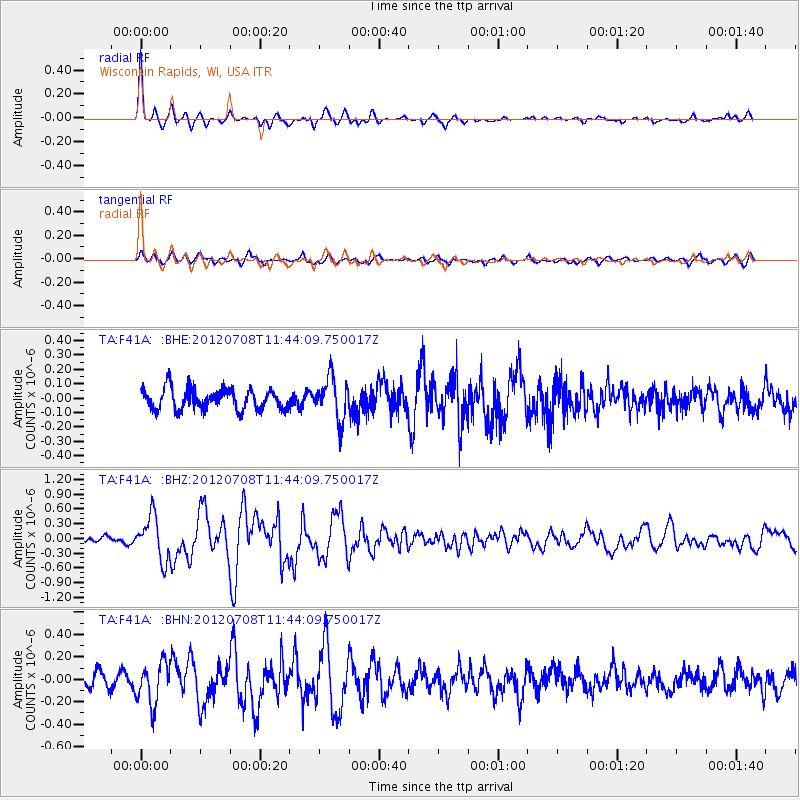
Signal To Noise
| Channel | StoN | STA | LTA |
| TA:F41A: :BHZ:20120708T11:44:09.750017Z | 6.9094577 | 4.446143E-7 | 6.4348654E-8 |
| TA:F41A: :BHN:20120708T11:44:09.750017Z | 3.1824872 | 1.8302683E-7 | 5.7510622E-8 |
| TA:F41A: :BHE:20120708T11:44:09.750017Z | 2.0342472 | 1.452836E-7 | 7.141885E-8 |
| Arrivals |
| Ps | 5.2 SECOND |
| PpPs | 15 SECOND |
| PsPs/PpSs | 20 SECOND |


