You are here: Home > Network List > TA - USArray Transportable Network (new EarthScope stations) Stations List
> Station F42A Maple Grove Farm, Niagara, WI, USA > Earthquake Result Viewer
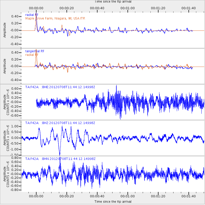
F42A Maple Grove Farm, Niagara, WI, USA - Earthquake Result Viewer

| Earthquake location: |
Kuril Islands |
| Earthquake latitude/longitude: |
45.5/151.3 |
| Earthquake time(UTC): |
2012/07/08 (190) 11:33:02 GMT |
| Earthquake Depth: |
20 km |
| Earthquake Magnitude: |
5.7 MB, 5.6 MS, 6.0 MW, 5.8 MW |
| Earthquake Catalog/Contributor: |
WHDF/NEIC |
|
| Network: |
TA USArray Transportable Network (new EarthScope stations) |
| Station: |
F42A Maple Grove Farm, Niagara, WI, USA |
| Lat/Lon: |
45.76 N/88.13 W |
| Elevation: |
358 m |
|
| Distance: |
75.1 deg |
| Az: |
38.587 deg |
| Baz: |
321.2 deg |
| Ray Param: |
0.05187308 |
| Estimated Moho Depth: |
19.0 km |
| Estimated Crust Vp/Vs: |
1.94 |
| Assumed Crust Vp: |
6.41 km/s |
| Estimated Crust Vs: |
3.304 km/s |
| Estimated Crust Poisson's Ratio: |
0.32 |
|
| Radial Match: |
91.457375 % |
| Radial Bump: |
400 |
| Transverse Match: |
63.604652 % |
| Transverse Bump: |
400 |
| SOD ConfigId: |
466652 |
| Insert Time: |
2013-02-21 01:15:03.742 +0000 |
| GWidth: |
2.5 |
| Max Bumps: |
400 |
| Tol: |
0.001 |
|
Signal To Noise
| Channel | StoN | STA | LTA |
| TA:F42A: :BHZ:20120708T11:44:12.14998Z | 5.9713807 | 4.427887E-7 | 7.4151814E-8 |
| TA:F42A: :BHN:20120708T11:44:12.14998Z | 1.9381485 | 1.8038716E-7 | 9.30719E-8 |
| TA:F42A: :BHE:20120708T11:44:12.14998Z | 1.5774294 | 1.6012196E-7 | 1.0150816E-7 |
| Arrivals |
| Ps | 2.9 SECOND |
| PpPs | 8.5 SECOND |
| PsPs/PpSs | 11 SECOND |


