You are here: Home > Network List > TA - USArray Transportable Network (new EarthScope stations) Stations List
> Station E43A Lone Tree Farm, Eben Junction, MI, USA > Earthquake Result Viewer
E43A Lone Tree Farm, Eben Junction, MI, USA - Earthquake Result Viewer
| Earthquake location: |
Kuril Islands |
| Earthquake latitude/longitude: |
45.5/151.3 |
| Earthquake time(UTC): |
2012/07/08 (190) 11:33:02 GMT |
| Earthquake Depth: |
20 km |
| Earthquake Magnitude: |
5.7 MB, 5.6 MS, 6.0 MW, 5.8 MW |
| Earthquake Catalog/Contributor: |
WHDF/NEIC |
|
| Network: |
TA USArray Transportable Network (new EarthScope stations) |
| Station: |
E43A Lone Tree Farm, Eben Junction, MI, USA |
| Lat/Lon: |
46.38 N/87.00 W |
| Elevation: |
303 m |
|
| Distance: |
75.1 deg |
| Az: |
37.547 deg |
| Baz: |
321.751 deg |
| Ray Param: |
0.05186586 |
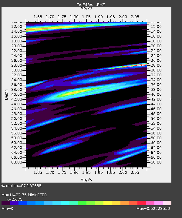
| Estimated Moho Depth: |
27.75 km |
| Estimated Crust Vp/Vs: |
2.08 |
| Assumed Crust Vp: |
6.472 km/s |
| Estimated Crust Vs: |
3.119 km/s |
| Estimated Crust Poisson's Ratio: |
0.35 |
|
| Radial Match: |
87.183655 % |
| Radial Bump: |
400 |
| Transverse Match: |
72.92545 % |
| Transverse Bump: |
400 |
| SOD ConfigId: |
466652 |
| Insert Time: |
2013-02-21 01:15:41.049 +0000 |
| GWidth: |
2.5 |
| Max Bumps: |
400 |
| Tol: |
0.001 |
|

Signal To Noise
| Channel | StoN | STA | LTA |
| TA:E43A: :BHZ:20120708T11:44:12.200029Z | 6.787358 | 5.2648903E-7 | 7.756907E-8 |
| TA:E43A: :BHN:20120708T11:44:12.200029Z | 1.7184186 | 1.154063E-7 | 6.715843E-8 |
| TA:E43A: :BHE:20120708T11:44:12.200029Z | 4.215527 | 2.187094E-7 | 5.1881862E-8 |
| Arrivals |
| Ps | 4.7 SECOND |
| PpPs | 13 SECOND |
| PsPs/PpSs | 18 SECOND |


