You are here: Home > Network List > TA - USArray Transportable Network (new EarthScope stations) Stations List
> Station F43A Flat Rock, Escanaba, MI, USA > Earthquake Result Viewer
F43A Flat Rock, Escanaba, MI, USA - Earthquake Result Viewer
| Earthquake location: |
Kuril Islands |
| Earthquake latitude/longitude: |
45.5/151.3 |
| Earthquake time(UTC): |
2012/07/08 (190) 11:33:02 GMT |
| Earthquake Depth: |
20 km |
| Earthquake Magnitude: |
5.7 MB, 5.6 MS, 6.0 MW, 5.8 MW |
| Earthquake Catalog/Contributor: |
WHDF/NEIC |
|
| Network: |
TA USArray Transportable Network (new EarthScope stations) |
| Station: |
F43A Flat Rock, Escanaba, MI, USA |
| Lat/Lon: |
45.83 N/87.17 W |
| Elevation: |
233 m |
|
| Distance: |
75.5 deg |
| Az: |
37.994 deg |
| Baz: |
321.739 deg |
| Ray Param: |
0.051631704 |
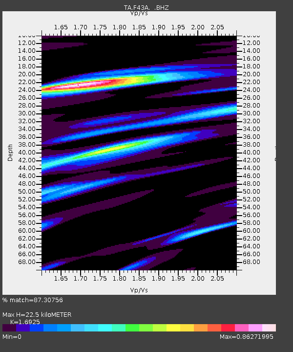
| Estimated Moho Depth: |
22.5 km |
| Estimated Crust Vp/Vs: |
1.69 |
| Assumed Crust Vp: |
6.53 km/s |
| Estimated Crust Vs: |
3.858 km/s |
| Estimated Crust Poisson's Ratio: |
0.23 |
|
| Radial Match: |
87.30756 % |
| Radial Bump: |
400 |
| Transverse Match: |
74.782234 % |
| Transverse Bump: |
400 |
| SOD ConfigId: |
466652 |
| Insert Time: |
2013-02-21 01:16:16.210 +0000 |
| GWidth: |
2.5 |
| Max Bumps: |
400 |
| Tol: |
0.001 |
|
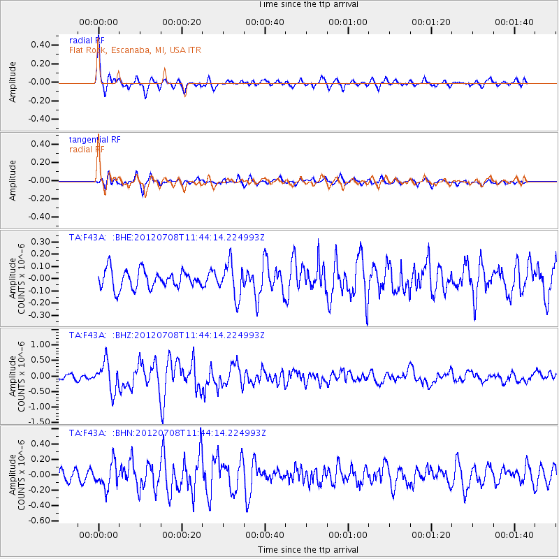
Signal To Noise
| Channel | StoN | STA | LTA |
| TA:F43A: :BHZ:20120708T11:44:14.224993Z | 4.8127947 | 4.7751723E-7 | 9.921828E-8 |
| TA:F43A: :BHN:20120708T11:44:14.224993Z | 2.888377 | 1.6875522E-7 | 5.8425616E-8 |
| TA:F43A: :BHE:20120708T11:44:14.224993Z | 1.9476267 | 1.426053E-7 | 7.3220036E-8 |
| Arrivals |
| Ps | 2.5 SECOND |
| PpPs | 9.0 SECOND |
| PsPs/PpSs | 11 SECOND |


