You are here: Home > Network List > TA - USArray Transportable Network (new EarthScope stations) Stations List
> Station F44A Big Bay de Noc Black Bears, Cooks, MI, USA > Earthquake Result Viewer
F44A Big Bay de Noc Black Bears, Cooks, MI, USA - Earthquake Result Viewer

| Earthquake location: |
Kuril Islands |
| Earthquake latitude/longitude: |
45.5/151.3 |
| Earthquake time(UTC): |
2012/07/08 (190) 11:33:02 GMT |
| Earthquake Depth: |
20 km |
| Earthquake Magnitude: |
5.7 MB, 5.6 MS, 6.0 MW, 5.8 MW |
| Earthquake Catalog/Contributor: |
WHDF/NEIC |
|
| Network: |
TA USArray Transportable Network (new EarthScope stations) |
| Station: |
F44A Big Bay de Noc Black Bears, Cooks, MI, USA |
| Lat/Lon: |
45.97 N/86.42 W |
| Elevation: |
234 m |
|
| Distance: |
75.7 deg |
| Az: |
37.479 deg |
| Baz: |
322.146 deg |
| Ray Param: |
0.05149027 |
| Estimated Moho Depth: |
43.5 km |
| Estimated Crust Vp/Vs: |
1.76 |
| Assumed Crust Vp: |
6.53 km/s |
| Estimated Crust Vs: |
3.716 km/s |
| Estimated Crust Poisson's Ratio: |
0.26 |
|
| Radial Match: |
84.75397 % |
| Radial Bump: |
400 |
| Transverse Match: |
70.3442 % |
| Transverse Bump: |
400 |
| SOD ConfigId: |
466652 |
| Insert Time: |
2013-02-21 01:16:41.004 +0000 |
| GWidth: |
2.5 |
| Max Bumps: |
400 |
| Tol: |
0.001 |
|
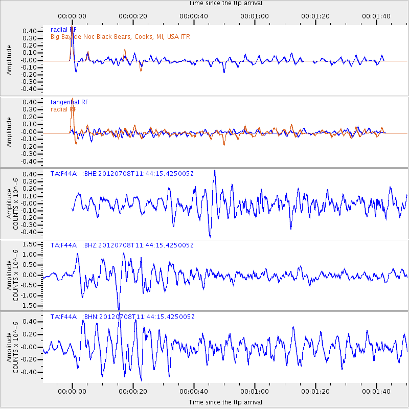
Signal To Noise
| Channel | StoN | STA | LTA |
| TA:F44A: :BHZ:20120708T11:44:15.425005Z | 5.945801 | 5.6454115E-7 | 9.494787E-8 |
| TA:F44A: :BHN:20120708T11:44:15.425005Z | 3.4612389 | 2.1791696E-7 | 6.295924E-8 |
| TA:F44A: :BHE:20120708T11:44:15.425005Z | 1.8339669 | 1.4237578E-7 | 7.763269E-8 |
| Arrivals |
| Ps | 5.2 SECOND |
| PpPs | 18 SECOND |
| PsPs/PpSs | 23 SECOND |


